Tsarigrad Peak
| Tsarigrad Peak | ||
|---|---|---|
|
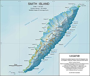
Map of Smith Island with Tsarigrad Peak (below center) |
||
| height | 1760 m | |
| location | Smith Island , South Shetland Islands | |
| Mountains | Imeon Range | |
| Coordinates | 63 ° 0 '53 " S , 62 ° 34' 42" W | |
|
|
||
The Tsarigrad Peak (English; Bulgarian връх Цариград wrach Zarigrad ) is a 1760 m high mountain on Smith Island in the archipelago of the South Shetland Islands . In the Imeon Range, it rises 2.5 km from Mount Foster , 0.55 km south of Slaveykov Peak and 0.6 km northeast of Neofit Peak . The Armira Glacier lies southeast of it.
Bulgarian scientists mapped it in 2009. The Bulgarian Commission for Antarctic Geographical Names named it in the same year after the Conference of Constantinople (in Bulgaria called Constantinople Tsarigrad ) between 1876 and 1877, at which the ethnic boundaries of Bulgaria were determined.
Web links
- Tsarigrad Peak in the Composite Gazetteer of Antarctica (English)

