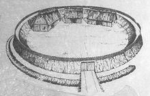
Ring wall of the castle
| Ring wall of the castle | ||
|---|---|---|
|
Exterior view of the wall |
||
| Creation time : | 900 to 1000 | |
| Castle type : | Niederungsburg | |
| Conservation status: | Wall and moat | |
| Place: | Celle - Altencelle | |
| Geographical location | 52 ° 35 '7 " N , 10 ° 5' 29.7" E | |
|
|
||

The ring wall of Burg is an early medieval hill fort near Altencelle , a district of Celle in Lower Saxony . The complex from around the 10th century probably served the population as a refuge in inaccessible marshland on the Fuhse . Today, with its 3 m high ring wall, it is one of the most important early medieval cultural monuments in Celle.
location
The ring wall of Burg is located several hundred meters west of the Altencell district of Burg. The weir system used to be on a sand dune in the middle of the extensive lowland area of the Fuhse. At that time, the river passed north of the castle, because in addition to the ring wall, a wall was built in the south with a ditch in front. Today the water flows south past the facility.
description
Despite the agricultural use of the surrounding area in the past centuries, the almost circular rampart with a diameter of 70 to 85 m and an inner area of around 0.2 hectares is well preserved. It still has its original height of around 3 m. The wall was built from plagues . In front of it was a dry pointed ditch 2 m deep and 6 m wide. Between the wall and the ditch there was a 5 m wide berm . The ditch was interrupted by an earth bridge, which led to the only access to the facility on the east side, still visible today through a break in the wall. In the north was the Fuhse, which at that time flowed by about 50 m away.
A stone staircase was built for visitors that leads to the wall. In front of the wall there is a notice board with explanations of the historical significance of the complex.
Excavations
The first archaeological investigation with a section through the wall profile was carried out by the archaeologist Carl Schuchhardt in 1906 . He discovered that the wall had been built from Plaggen , remnants of earlier wooden stiffeners were not found.
A second excavation took place from 1935 to 1936 by the historian Ernst Sprockhoff . He exposed a good third of the area inside the wall. In this post holes found that would include three buildings in the immediate vicinity Wall. They can be interpreted as a 20 × 7 m hall building , ancillary and storage building . The entrance, which consisted of a 3 × 5 m gate lane bordered by wooden posts, was also found in the wall. The finds related to the castle consisted of ceramic shards, a rusted knife and several horseshoes. They were dated to the 10th century. The finds indicated only a short period of settlement. Facilities of a similar structure were not uncommon in the lowlands and were built between the 8th and 12th centuries as refuges for the population.
Stone Age flints and fireplaces were also found during the excavation . They indicated that there was already a settlement on the sand dune in the lowland area of the Fuhse in the Stone Age.
reception
The well-preserved Wallburg became famous again at the beginning of the 20th century. The novel Der Wehrwolf by Hermann Löns made sure of that . Löns was inspired by the layout and relocated parts of the plot that took place during the Thirty Years' War to this location. Then marauders and other warriors roamed the country and plundered the farms of the heather farmers . They withdrew to an old refugee castle . According to Lön's novel, they fortified the complex and built houses inside the wall. There they successfully defended themselves against an attack by Swedish mercenaries .
literature
- Ralf Busch : The castle in Altencelle: its excavation and the historical environment , Celle, 1990, ISBN 3-925902-10-4
- Ralf Ebelt: The ring wall near Burg / Altencelle: An Ottonian refuge? in: Reports on the preservation of monuments in Lower Saxony , 3/1999
- Ernst Andreas Friedrich : The castle of Burg near Altencelle , pp. 32–34, in: If stones could talk . Volume IV, Landbuch-Verlag, Hannover 1998, ISBN 3-7842-0558-5
Web links
- Entry by Sandy Bieler on the ring wall of Burg in the scientific database " EBIDAT " of the European Castle Institute
- Lönswall in the Lower Saxony Monument Atlas
- Reconstruction drawing by Wolfgang Braun


