River Twiss
| River Twiss | ||
|
River Twiss with the Ingleton Viaduct |
||
| Data | ||
| location | North Yorkshire , England | |
| River system | River Lune | |
| Drain over | River Greta → River Lune → Morecambe Bay | |
| River basin district | North West | |
| source | Kingsdale Head 54 ° 12 ′ 42 " N , 2 ° 26 ′ 56" W. |
|
| Source height | 303 m | |
| Union | with the River Doe to the River Greta Coordinates: 54 ° 9 ′ 12 ″ N , 2 ° 28 ′ 15 ″ W 54 ° 9 ′ 12 ″ N , 2 ° 28 ′ 15 ″ W |
|
| Mouth height | 118 m | |
| Height difference | 185 m
|
|
| Communities | Ingleton | |
| Two waterfalls: Thornton Force, Pecca Falls | ||
The River Twiss is a small river in North Yorkshire , England . The River Twiss is also called Kingsdale Beck in its upper reaches and is formed at Kingsdale Head from the Buck Beck and the Long Gill, which flow from the western flank of the Whernside , and the Back Gill.
The River Twiss flows south and unites in Ingleton with the River Doe to form the River Greta .
water falls
Along the Twiss and Doe rivers , the Ingleton Waterfalls Trail runs alongside the falls and rapids on both rivers.
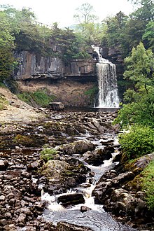
The Thornton Force waterfall is one of the two waterfalls of the River Twiss. In this waterfall, the river falls about 46 m over a step. The painter William Turner made a drawing of this waterfall in 1816, which is now owned by the Tate Gallery .
The Pecca Falls waterfall consists of three stages, in each of which the river first falls into a small basin and thus overcomes a height difference of 30 m.


