Rivière Saint-Charles
| Rivière Saint-Charles | ||
|
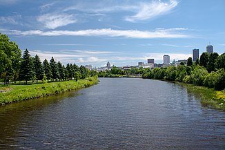
Rivière Saint-Charles from the Pont Drouin |
||
| Data | ||
| location | Capitale-Nationale in Québec (Canada) | |
| River system | Saint Lawrence River | |
| Drain over | Saint Lawrence River → Atlantic Ocean | |
| origin |
Lac Saint-Charles 46 ° 54 ′ 39 ″ N , 71 ° 22 ′ 17 ″ W. |
|
| Source height | 150 m | |
| muzzle |
St. Lawrence River Coordinates: 46 ° 49 ′ 39 ″ N , 71 ° 11 ′ 50 ″ W 46 ° 49 ′ 39 ″ N , 71 ° 11 ′ 50 ″ W
|
|
| length | approx. 35 km | |
| Catchment area | 513 km² | |
| Discharge at the gauge 0.8 km above Rivière Lorette ( ⊙ ) A Eo : 357 km²
|
MQ 1969/2001 Mq 1969/2001 |
8 m³ / s 22.4 l / (s km²) |
| Big cities | Quebec | |
| Residents in the catchment area | 350000 | |
|
The catchment area of the Rivière Saint-Charles |
||
The Rivière Saint-Charles is a left tributary of the Saint Lawrence River in the Capitale-Nationale administrative region of the Canadian province of Québec .
The Rivière Saint-Charles forms the outflow of the outflow -regulated Lac Saint-Charles, 20 km north of Québec . It flows in a southerly direction, initially strongly meandering , to La Haute-Saint-Charles , a north-western district of Québec. Later he gradually turns east. Its river course lies entirely within the city limits of Québec. On the last third of its stretch of flow, it flows through downtown Québec and finally flows north of Old Québec into the Saint Lawrence River. The river has a length of about 35 km. Its catchment area covers 513 km². With a population of 350,000, it is the most densely populated catchment area in the province of Québec.
The Parc linéaire des rivières Saint-Charles et du Berger follows the entire course of the river . The 28 m high waterfall Kabir Kouba is located near Wendake .
Web links
Individual evidence
- ^ Commission de toponymie du Québec: Rivière Saint-Charles
- ↑ Bureau audiences publiques sur l'environnement (PDF; 103 kB)
- ↑ Water Survey of Canada - Station 02PD010 ( Memento of the original from December 24, 2010) Info: The archive link was automatically inserted and not yet checked. Please check the original and archive link according to the instructions and then remove this notice.

