Rivne (Drohobych)
| Rivne | ||
| Рівне | ||

|
|
|
| Basic data | ||
|---|---|---|
| Oblast : | Lviv Oblast | |
| Rajon : | Drohobych district | |
| Height : | 305 m | |
| Area : | 0.676 km² | |
| Residents : | 200 (2001) | |
| Population density : | 296 inhabitants per km² | |
| Postcodes : | 82163 | |
| Area code : | +380 3244 | |
| Geographic location : | 49 ° 23 ' N , 23 ° 47' E | |
| KOATUU : | 4621284305 | |
| Administrative structure : | 3 villages | |
| Mayor : | Petro Bochonok | |
| Address: | вул. Богдана Хмельницького 76 82 163 с. Летня |
|
| Statistical information | ||
|
|
||
Riwne (Ukrainian Рівне ; Russian Ровное / Rownoje , Polish Równe , German Königsau ) is a village in the western Ukrainian oblast Lwiw with about 200 residents.
The village belongs together with the villages Letnja (Летня) and Korosnyzja the District Municipality Letnja.
history
During the first partition of Poland , the chamber estates of the city of Drohobych became part of the new Kingdom of Galicia and Lodomeria of the Habsburg Empire (from 1804).
The village was established in 1783 in the course of the Josephine colonization in the area of the dissolved Basilian monastery in Letnja . German colonists of the Catholic denomination were settled there. The colony was called Königsau and became an independent municipality. A Roman Catholic parish was planned for the colony (only three Josephine colonies should have one, in addition to Königsau: Kaisersdorf and Wiesenberg ).
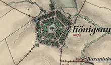
As the only colony in Galicia, Königsau was arranged according to a regular pentagon.
In 1900 the municipality of Königsau, Równe had 114 houses with 660 inhabitants, of which 631 were German-speaking, 19 Polish-speaking, 10 Ruthenian-speaking, 642 Roman Catholic, 10 Greek-Catholic, and 8 of other faiths.
After the end of the First World War in 1918 and the collapse of the Austro-Hungarian monarchy, Königsau became part of Poland.
In 1921 the community of Równe (Königsau) had 117 houses with 748 inhabitants, of which 647 were Germans, 56 Poles, 42 Ruthenians, 3 Jews (nationality), 684 Roman Catholic, 40 Greek Catholic, 21 Protestant, 3 Jews (religion) .
During the Second World War it belonged first to the Soviet Union and from 1941 to the General Government, from 1945 back to the Soviet Union, now part of the Ukraine .
The Germans were resettled in 1940 as a result of the German-Soviet border and friendship treaty.
In 1993 the former Roman Catholic church was demolished.
literature
- Maria Schuster: Königsau. A village in Galicia through the ages. Würzburg 2012.
- Koenigsau . In: Filip Sulimierski, Władysław Walewski (eds.): Słownik geograficzny Królestwa Polskiego i innych krajów słowiańskich . tape 4 : Kęs – Kutno . Walewskiego, Warsaw 1883, p. 243 (Polish, edu.pl ).
Web links
- Impressions from the former Königsau, Galicia (today Rivne), Ukraine (PDF; 383 kB). Aid Committee of the Galiziendeutschen eV Publication from February 2012. Accessed on December 12, 2016.
- Königsau - A German Catholic village in Galicia
Individual evidence
- ↑ Central Electoral Commission of Ukraine ( Memento of the original from June 26, 2016 in the Internet Archive ) Info: The archive link was inserted automatically and has not yet been checked. Please check the original and archive link according to the instructions and then remove this notice.
- ↑ Henryk Lepucki: Działalność kolonizacyjna Marii Teresy i Józefa II w Galicji 1772-1790: z 9 tablicami i MAPA . Kasa im. J. Mianowskiego, Lwów 1938, p. 163-165 (Polish, online ).
- ↑ a b Grzegorz Rąkowski: Ukraińskie Karpaty i Podkarpacie, część zachodnia. Przewodnik krajoznawczo-historyczny . Oficyna Wydawnicza "Rewasz", Pruszków 2013, ISBN 978-83-62460-31-1 , p. 212-213 (Polish).
- ↑ Ludwig Patryn (Ed.): Community encyclopedia of the kingdoms and countries represented in the Reichsrat, edited on the basis of the results of the census of December 31, 1900, XII. Galicia . Vienna 1907.
- ↑ Główny Urząd Statystyczny: Skorowidz miejscowości Rzeczypospolitej Polskiej. Tom XIII. Województwo lwowskie . Warszawa 1924 (Polish, online [PDF]).


