Roja
| Roja | ||
|---|---|---|
 Help on coat of arms |
|
|
| Basic data | ||
| State : |
|
|
| Landscape: | Courland ( Latvian : Kurzeme ) | |
| Administrative district : | Rojas novads | |
| Coordinates : | 57 ° 30 ' N , 22 ° 49' E | |
| Residents : | 2,500 (Jun 3, 2015) | |
| Area : | ||
| Population density : | ||
| Height : | 6 m | |
| Website: | www.roja.lv | |
| Post Code: | ||
| ISO code: | ||
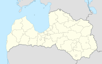
Roja (German: Rojen, also: Rohjen) is a place in western Latvia , on the coast of the Bay of Riga , and the center of the administrative unit of the same name. Roja is located at the mouth of the Roja River of the same name .
history
The place was first mentioned in writing in 1387 as "villa Roye" as a trading center and port of the Bishop of Riga.
During the First World War , Roja was occupied by German troops in 1915. For better transport connections to the port of Roja, they had a narrow-gauge railway built to Stende , where it met the Ventspils - Jelgava line .
A fish canning factory was established in the 1960s.
From 2008 to 2010 there was an administrative unit with the neighboring Mērsrags .
Port and shipping
In the 16th century, Roja was one of the three ports in Courland that were allowed to sell goods abroad. By sea was Roja access to temporary significant Curonian trading center Saßmacken . In the 19th century Roja was a center of shipbuilding on the Baltic coast of the Baltic Sea. In 1875 a shipping school was founded. In addition, a line connection by steamship to Riga was set up. Then Roja developed into a (modest) seaside resort.
literature
- Hans Feldmann , Heinz von zur Mühlen (ed.): Baltic historical local dictionary, part 2: Latvia (southern Livonia and Courland). Böhlau, Cologne 1990, ISBN 3-412-06889-6 , pp. 515-516.
- Astrīda Iltnere (ed.): Latvijas Pagasti, Enciklopēdija. Preses Nams, Riga 2002, ISBN 9984-00-436-8 .
Footnotes
- ↑ a b c d Hans Feldmann, Heinz von zur Mühlen (ed.): Baltic historical local dictionary, part 2: Latvia (southern Livonia and Courland). Böhlau, Cologne 1990, p. 516.
- ↑ Hans Feldmann, Heinz von zur Mühlen (ed.): Baltic historical local dictionary, part 2: Latvia (southern Livland and Courland). Böhlau, Cologne 1990, p. 547.

