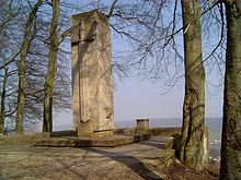
Sondershausen roundabout


The roundabout of Sondershausen is a 1910 built semi rondell with 1929 eingeweihtem World War - Memorial on the ridge Hainleite in Thuringia Kyffhäuserkreis . At 390 m above sea level Located above sea level , it serves as a vantage point down to the Sondershausen core city and the Harz Mountains .
Geographical location
The roundabout is located on the upper edge of the northern steep drop of the Hainleite, which drops into the valley through which the Wipper tributary Bebra flows and with the core town of Sondershausen. 1.8 km west of the approximately 630 m north-northeast of the summit of the Dorn ( 411.2 m ) and 394 m above sea level is Bebra an der Bebra and 2 km east of Jecha an der Wipper, two districts of Sondershausen.
Viewed in a south-north direction, a street leads from the Sondershausen district of Oberspier past the Possen building ensemble to the roundabout in the north, which is mostly straight, 5.2 km long and, viewed in the direction of the route, is called Possenweg , Kastanienallee and Possenwaldstrasse (or Dornallee ); The forest path Prinzessinnenweg leads past the roundabout .
The Spatenberg ( 366.1 m ) with the Spatenberg Tower is located about 470 m east-southeast of the roundabout . On the Kammweg (Göldner-Rundweg) leading to the observation tower , you can see cracks and crevices in the rock, which could have been caused by the earthquake of January 25, 1348.
Rondel with memorial
Roundabout
A wooden pavilion or something similar must have existed at this vantage point as early as 1854. From this year it can be read in documents handed down that the special house prince paid a bill for carpentry work on the roundabout. The semicircle was built in 1910 on a stone plateau on behalf of the special houses transport and embellishment association. The suggestion for this was given by the chairman of the Sondershäuser Harz Club Association, Otto Burkhardt (1869–1956).
cenotaph
The memorial standing on the roundabout consists of a square column made of shell limestone . It commemorates soldiers of the “ Special Houses Association of Academic-Musical Associations” who died in both world wars .
The decision to erect a memorial near Sondershausen was made at the 1926 Association Festival in Königsberg . For this purpose, a festival main committee with the chairman Professor Karl Friesland from Hanover was appointed. At first, a simple stone cross was thought of, which should stand on the Frauenberg in an honorary grove. Then there was the proposal to design the lower area of the Spatenberg Tower on the Spatenberg as a memorial. The mayor of the special houses, Schlufter, helped decide that the most favorable place for the erection of the monument would be the roundabout. After buying a block of granite (3.60 m high) from the Harz Mountains, the decision was made for “a monument with a simple, cuboid structure made of indigenous limestone ”. The construction of the memorial began in September 1928. The memorial was inaugurated for the 3rd big association festival on Pentecost Sunday, May 19, 1929.
The inscription on the north side of the column reads: “1914–1918” and “1939–1945”. Below is a plaque with text: "The Special Houses Association of German Singers Connections / Brothers Fallen in World War II".
Lookout point
The roundabout offers good prospects in northern directions: the view falls on the core town of Sondershausen, which is about 200 m lower in the valley of the Bebra , in the north and the valley of the Wipper, which runs northeast of it, with the Windleite beyond it , to the Frauenberg (Hainleite) in the northwest , to the Kyffhäuser mountains in the east-northeast and to the Harz with the Brocken in the north-northwest.
On the edge of the plateau on the slope side, in the northern center of the roundabout, a sandstone column with an arrow board was set up, on which sighting targets with distances in miles and the roundabout height ( 390 m above sea level ) are indicated.
See also
General sources
- Helmut Köhler: “To the SV memorial”. In: Sondershäuser Heimatecho (Official Gazette of the City of Sondershausen), Issues 7/2005, 8/2005, 12/2005.
Individual evidence
- ↑ a b c arrow board at the roundabout u. a. with altitude indication 390 m above sea level NN
- ↑ Photo of the memorial texts on commons.wikimedia.org
Web links
Coordinates: 51 ° 21 ′ 33.2 " N , 10 ° 51 ′ 48.6" E

