Rote Wand (Grazer Bergland)
| Red wall | ||
|---|---|---|
|
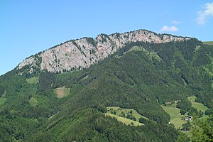
Red wall from the southeast |
||
| height | 1505 m above sea level A. | |
| location | Styria , Austria | |
| Mountains | Grazer Bergland , foothills east of the Mur | |
| Dominance | 2.7 km → Hochlantsch | |
| Notch height | 310 m ↓ Teichalm | |
| Coordinates | 47 ° 20 '0 " N , 15 ° 24' 25" E | |
|
|
||
| rock | Hochlantschkalk , dolomite | |
| Age of the rock | Devon | |
The Rote Wand is a mountain in the Grazer Bergland and has a height of 1505 m above sea level. A. The name Rote Wand comes from the south-east facing demolition, which consists of partly red-colored lime . The area is famous for its ibex colony and for the Bärenschützklamm between the Roter Wand and Hochlantsch . There are numerous climbing routes on the Rote Wand .
Normal way
An often overloaded parking lot above Tyrnau (approx. 880 m) is a suitable starting point for a circular hike. The ascent to the summit via the Bucheben takes about 2 hours, the descent is via the Tyrnauer Alm (Jausenhütte) and takes about 1½ hours. The mountain range can be crossed either from the southwest (as described) or from the northeast.
Web links
Commons : Rote Wand (Grazer Bergland) - Collection of images, videos and audio files

Red wall in winter from Schöckl seen from


