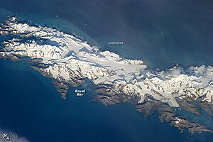
Royal Bay
| Royal Bay | ||
|---|---|---|
|
Satellite image of South Georgia with Royal Bay |
||
| Waters | South Atlantic | |
| Land mass | South Georgia | |
| Geographical location | 54 ° 32 ′ 39 ″ S , 36 ° 0 ′ 33 ″ W | |
|
|
||
| width | 6 km | |
| depth | 8 kilometers | |
| Islands | Harcourt Island | |
| Tributaries | Hindle Glacier , Ross Glacier | |
|
Royal Bay on Cook's Map (South is Up) |
||
The Royal Bay is a 6 km wide and 8 km deep bay on the north coast of South Georgia . The entrance to the bay is between Cape Charlotte and Cape Harcourt .
In the west, the 10 km long Ross Glacier flows into the bay at a width of 4 km. The Weddell Glacier flows in the south . The Royal Bay is surrounded by mountains up to 2000 m high.
As in many other places in the area, many birds breed here, including king penguins , gentoo penguins and cormorants .
history
Royal Bay was discovered and named in 1775 by a British expedition under James Cook .
In 1882, as part of the International Polar Year, a German expedition under Carl Schrader was sent to observe the Venus transit and to carry out regular weather observations and measurements of the earth's magnetic field for a year . This group was stationed on the north bank of the bay until 1883. Their anchorage was named Moltke-Hafen after the SMS Moltke , the ship of the expedition team and at the same time the first motorized ship to reach South Georgia .
Web links
- Royal Bay in the Geographic Names Information System of the United States Geological Survey (English)
- Royal Bay on geographic.org (English)
Individual evidence
- ^ Susan Barr, Cornelia Lüdecke: South Georgia . In: Susan Barr, Cornelia Lüdecke (Ed.): The History of the International Polar Years (IPYs) . Springer, Berlin and Heidelberg 2010, ISBN 978-3-642-12401-3 , pp. 54–58 , doi : 10.1007 / 978-3-642-12402-0 ( limited preview in Google Book search).


