São José dos Ausentes
| São José dos Ausentes | ||
|---|---|---|
|
Coordinates: 28 ° 45 ′ S , 50 ° 4 ′ W São José dos Ausentes on the map of Rio Grande do Sul
|
||
| Basic data | ||
| Country | Brazil | |
| State | Rio Grande do Sul | |
| City foundation | March 20, 1992 | |
| Residents | 3290 (IBGE / 2010) | |
| Detailed data | ||
| surface | 1,176.685 km 2 | |
| Population density | 2.8 inhabitants / km 2 | |
| height | 1200 m | |
| Time zone | UTC −3 | |
| Website | ||
| Location of São José dos Ausentes in Rio Grande do Sul | ||
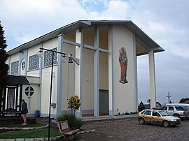
| Church in São José dos Ausentes | ||
Sao Jose dos Ausentes (short often Ausentes ) is the easternmost city in the state of Rio Grande do Sul in southern Brazil . It is located about 230 km northeast of Porto Alegre with 3527 inhabitants (estimate as of 2019). Neighboring are the places Bom Jesus , Jaquirana , Cambará do Sul and other places in Santa Catarina . São José dos Ausentes was originally part of the Bom Jesus municipality.
tourism
With São Joaquim and Urupema in the neighboring state of Santa Catarina, Ausentes is one of the coldest places in Brazil with regular snowfall and frost in winter. The 1400 meter high Pico do Monte Negro is the highest mountain in Rio Grande do Sul. The municipal area is dominated by farms with horse breeding and corresponding tourism. There are also hikes through gorges, to waterfalls such as the Cachoeirão dos Rodrigues , and on Monte Negro .
Web links
- Information in Portuguese
- IBGE to São José dos Ausentes. (Brazilian Portuguese, updated statistics).


