Saguia el Hamra (river)
| Saguia el Hamra | ||
|
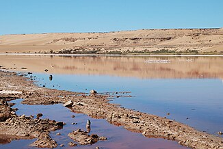
Lagoon below the dam with reddish water between the northern outskirts of Aaiún and a military area behind the hill |
||
| Data | ||
| location | Es Semara and Laayoune provinces , Western Sahara | |
| River system | Saguia el Hamra | |
| origin | Confluence of the Uad Laiaat and other wadis west of Farsia 27 ° 2 ′ 33 ″ N , 10 ° 44 ′ 59 ″ W |
|
| muzzle | west of El Aaiún as a dry valley in the Atlantic Coordinates: 27 ° 11 ′ 15 ″ N , 13 ° 23 ′ 29 ″ W, 27 ° 11 ′ 15 ″ N , 13 ° 23 ′ 29 ″ W
|
|
| length | 350 km as the crow flies | |
| Catchment area | 65,000 km² | |
| Big cities | El Aaiún | |
Saguia el Hamra , Arabic الساقية الحمراء as-Saqiya al-hamra ' , DMG as-Sāqiya al-ḥamrāʾ' the red river bed ', is a temporarily water-bearing river ( wadi ) in the Western Sahara , aterritory administeredby Morocco . The course of the river gave its name to Saguia el Hamra , the northern of the two provinces in the former colony of Spanish Sahara .
geography
The geographical zone in the northeast of Western Sahara consists mainly of low vegetation, flat stone desert ( hammada ), which is interspersed with sand plains and rocky hills that only reach over 700 meters above sea level in the east near the Algerian border. The levels do not reach a height of more than 400 meters. The area extends from the foothills of the southern Atlas Mountains in Morocco to the Zemmour Mountains with its rugged rock formations of volcanic origin in the south. In between there is an extensive area with near-surface groundwater, where water collects in numerous smaller rivers at the end of the short rainy season in autumn. Precipitation usually falls as short, violent thunderstorms. The umbrella acacia Acacia tortilis subsp. raddiana ( hassania : talkha ) is the most common tree that can be seen standing alone in the brown, stony plain outside the oases; like the Verek acacia ( Acacia senegal ) , which also occurs in some places, it has been used for centuries to extract gum arabic .
The only significant river in the north to which several smaller watercourses flow is the Saguia el Hamra. The southern part of the former Spanish colony derives its name from its counterpart Rio de Oro . The watercourses of the Saguia el Hamra drain an area of around 65,000 km 2 over a distance of 350 kilometers from the beginning of the river at Farsia in the east to its end on the outskirts of Aaiún in the west, 25 kilometers off the Atlantic coast .
Grains can be grown in some places along the river in oases . This includes the oasis of Smara, which, because of its good fresh water supply, was a campsite at the crossroads of caravan routes, where there was also pasture for camels. In the gardens by the river, date palms and Egyptian doum palms ( Hyphaene thebaica ) thrive , the fruits of which serve as bread substitutes.
The outflow of the Saguia el Hamra into the sea is blocked on the western outskirts of Aaiún by transverse sand hills, so that several, mostly contiguous, shallow lakes with reed banks form there in the rainy season. In the area of the city center, a dam dams the river for several kilometers.
In addition to this lagoon , the surface waters of the Western Sahara are limited to a few Gueltas , other pools and salt pans, which are also temporarily filled with rainwater; they evaporate to a large extent or seep into the ground. The river was named after the red-brown color of the water. In the middle of the sand dunes, the lakes of Aaiún offer one of the rare habitats for flamingos and kazarkas .
Individual evidence
- ^ János Besenyő: Western Sahara. (PDF; 3.5 MB) IDR Research, Publikon Publishers, Pécs 2009, p. 10f
- ↑ John Mercer: Spanish Sahara. George Allen & Unwin Ltd, London 1976, p. 24


