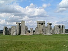
Salisbury Plain
Salisbury Plain is a chalk plateau of around 780 km² in central southern England and belongs to the southern English chalk formation . Most of the plain is in the county of Wiltshire north of Salisbury , the rest in Berkshire . The plain is known for its numerous archaeological sites, the most famous of which is Stonehenge . The sparsely populated region is used for forestry and agriculture. The plain and some surrounding areas are classified as an Area of Outstanding Natural Beauty .
The only major towns are Durrington and Amesbury . There are also numerous hamlets and military installations. Salisbury Plain has been one of the most important training grounds for the British Army for over 100 years due to its low population density. Larkhill is the cradle of military aviation in the United Kingdom, the oldest squadrons of the Royal Air Force were established here from 1911, but flight operations ceased in 1914. The Defense Science and Technology Laboratory , whose research work is largely secret, is located at Porton Down .
The main road A303 runs right through the plain . There are plans to build a tunnel to protect Stonehenge from the damage caused by the heavy traffic.
The plain was described by the writers William Wordsworth , Thomas Hardy and William Henry Hudson , while John Constable created numerous landscapes.
geography
The highest point is Walbury Hill in Berkshire, at 297 m . The plain is cut through by the river valleys of the River Wylye , the Avon and the Bourne . They all have a narrow river plain delimited by steep slopes and are relatively densely populated. Wylye and Bourne unite at Salisbury to form the Avon, which flows further south and flows into the English Channel at Christchurch .
The plain is bounded to the east by the Hampshire Downs and to the north by the Berkshire Downs , both chalk ridges. To the southwest are the Dorset Downs and Cranbourne Chase . In the west and northwest, namely in the Blackmore Vale, the Avon Vale and the Vale of Ardor, the chalk rock changes into clay and limestone . In the south lies the New Forest .
Since the army's extensive training grounds are not open to the public, numerous endangered animal and plant species can assert themselves there. There are two nature reserves , and in 2003 the Great Bustard was reintroduced on Salisbury Plain.
history
Salisbury Plain was settled during the Neolithic Age and the first inhabitants largely cleared the plain of the original vegetation. Initially, the population was concentrated in the causewayed camps of Whitesheet Hill and Robin Hood's Ball . It emerged Henge as Avebury and Durrington Walls . Around 2200 BC . Were BC Stonehenge and Avebury ceremonial priorities; Numerous round and elongated barrows date from this time . Around 600 BC Large Bronze Age hill forts were built at Scratchbury and Battlesbury . The remains of Roman roads , which probably opened up a settlement near Old Sarum, are still recognizable today . Villae rusticae are sparse, however, and later Anglo-Saxon field names suggest that the plains were primarily a state domain where crops were grown.
In the 6th century, Anglo-Saxon immigrants built settlements in the valleys surrounded by arable terraces , while the higher areas of the plain served as sheep pasture. To the south is the city of Salisbury , where the cathedral was built in the 13th and 14th centuries and was the tallest building in England for centuries. The cathedral is a reference to the prosperity that the wool and fabric trade brought to the region.
In the early modern period, a system of controlled-flooded water meadows was developed and large mansions were built around Salisbury. The Kennet and Avon Canal was built between 1794 and 1810 . In the middle of the 19th century, the wool and textile industry began to decline, which led to a decline in population. The sheep pastures were left to agriculture and the military. During this period of decline, Wiltshire became one of the poorest counties in England. In 1896 Guglielmo Marconi experimented with wireless telecommunications on Salisbury Plain and was able to send a signal over a distance of nearly two miles.
Web links
swell
- ↑ Highways Agency: Planned tunnel on the A303 near Stonehenge ( Memento from August 10, 2012)


