Salpa line
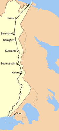
The Salpa Line ( Finnish : Salpalinja - cordon line) was a fortified line of defense along the eastern border of Finland . Its official name was Suomen Salpa ( Finnish bar ). The 1,200-kilometer Salpa Line was built between the end of the Winter War 1940 and the start of the Continuation War in 1941. The line stretched from the Gulf of Finland to Petsamo in Lapland . After the advance of the Red Army on the Karelian Isthmus came to a standstill in 1944 , the Salpa Line became superfluous and abandoned.
Construction of the line
After the start of the Soviet offensive on November 30, 1939, Finland tried to protect itself from late 1939 to early 1940 by hastily building three defense lines on the Karelian Peninsula. They were referred to as the Mannerheim Line (named after Carl Gustaf Emil Mannerheim ), the VT Line (Vammelsuu-Taipale) and the VKT-Line (Viipuri-Kuparsaari-Taipale).
From March 1940 work began on building another line of defense to strengthen the Karelian lines and also to protect the entire eastern flank of Finland. Initially volunteers and then unfit for war were used for the work. In the spring of 1941 the number of workers was nearly 35,000. After the resumption of war operations by a Soviet air raid on Finnish targets on June 25, 1941, the fortification work on the Salpa line was initially stopped and all armaments that had already been installed were moved from bunkers and command posts to the newly created front. Work on the Salpa Line resumed in early 1944 and continued until the end of the war after the Battle of Tali-Ihantala on September 4, 1944.
Fuse
728 different types of concrete structures, 315 kilometers of wire barriers , 225 kilometers of anti - tank barriers , 130 kilometers of tank trenches , more than 3,000 entrenchments , 254 infantry shelters, endless trenches and countless shelters made the line of defense very safe.
Old 23 and 28 cm grenade launchers from the late 19th century were also integrated along the coast . The numerous lakes, swamps and low rocky areas of the Saimaa lake area could be optimally included as geographical features in the course planning, as the entire area consisted of a labyrinth of lakes of different sizes, thousands of islands, canals and rivers, so that it was easy to defend . 90 percent of all concrete defense structures on the Salpa Line were located in the section between the Gulf of Finland and the Saimaa Lake District. This part was also called “Luumäki-Suomenlahti-linja” (Luumäki Gulf Line) or simply “Luumäki-linja”.
The fortifications were never involved in combat operations, as the Red Army was halted at the end of the Continuation War already in Karelia, long before their shock troops could reach the Salpa Line in summer 1944th At that time it was in parts only manned by reservists. But the very existence of this line of defense brought the Finns advantages in the subsequent peace negotiations .
Tank traps in Miehikkälä
Tank traps in Aholanvaara near Salla (Finland)
Tank traps in Aholanvaara near Salla (Finland)
Web links
- Salpa Center
- Salpa Line Museum (Finnish)
- Salpa-line within the North Fort (English)
Individual evidence
- ↑ a b Misc. Authors: Finland i Krig 1939–1940. ISBN 951-50-1182-5
- ↑ Salpazentrum, page SALPALINJA
- ↑ Salpazentrum, page Hankkeet


