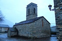
Samper (Huesca)
| Municipality of La Fueva: Samper | ||
|---|---|---|
 Place view
|
||
| coat of arms | Map of Spain | |
 Help on coat of arms |
|
|
| Basic data | ||
| Autonomous Community : |
|
|
| Province : | Huesca | |
| Comarca : | Sobrarbe | |
| Coordinates | 42 ° 26 ' N , 0 ° 17' E | |
| Height : | 747 msnm | |
| Residents : | 18 (2015) INE | |
| Postal code : | 22452 | |
| Area code: | 22113001800 | |
| administration | ||
| Website : | www.lafueva.com | |
Samper ( Aragonese Sant Per ) is a Spanish town in the Pyrenees in the province of Huesca in the autonomous community of Aragon . The place came in the 1960s as a district of Trillo to the municipality of La Fueva . Samper had 18 residents in 2015.
The place is northeast of the Embalse de Mediano on the N-260.
Architectural monuments
- San Pedro Church ( Bien de Interés Cultural )
Web links
Commons : Samper de Toledo de Lanata - collection of images, videos and audio files

