San Jose de Pocitos
| San Jose de Pocitos | ||
|---|---|---|
| Basic data | ||
| height | 583 m | |
| Telephone code | +591 (4) 68 | |
| Coordinates | 22 ° 3 ′ S , 63 ° 41 ′ W | |
|
|
||
| politics | ||
| Department | Tarija | |
| province | Gran Chaco Province | |
| climate | ||
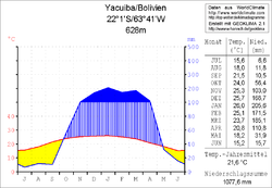
 Climate diagram Yacuiba |
||
San José de Pocitos is a place in the Tarija Department in southern Bolivia, right on the border with Argentina .
Location in the vicinity
San José de Pocitos (or short: Pocitos ) is südlichster area of Yacuiba and is (in the district Bolivian : Municipio ) Yacuiba in the Gran Chaco Province . Pocitos is located at an altitude of 583 m on the eastern edge of the Andes high mountains on the railway line between the cities of Santa Cruz in Bolivia and Salta in Argentina. The state border with Argentina runs along the southern edge of Pocitos, across the border is the Argentinian village of Profesor Salvador Mazza , also known as "Pocitos".
geography
San José de Pocitos has a warm and temperate climate with an annual average temperature of almost 22 ° C, the monthly values fall in the southern winter months of June and July to 15 ° C (see climate diagram Yacuiba) with warm day and cool night temperatures and are from October to March between 24 and 26 ° C.
The average annual precipitation is a little more than 1000 mm, the dry season with monthly values between 5 and 30 mm extends from May to September, this is countered by a distinct rainy season from December to March with more than 200 mm of precipitation in a month.
population
The population of the district has grown from 3,593 inhabitants (1992 census) to currently around 16,000 inhabitants in more than 3,500 families.
Individual evidence
- ↑ Instituto Nacional de Estadística (INE) 1992
- ↑ San José de Pocitos: Sesenta años de historia y custodia de la Frontera ( Spanish )
Web links
- San José de Pocitos: Sesenta años de historia y custodia de la Frontera ( Spanish )
- Municipio Yacuiba - Politics, Population and Economy ( Spanish )
- Municipio Yacuiba - General Maps No. 60301
- Municipio Yacuiba - detailed map and population data (PDF; 407 kB) ( Spanish )
- Departamento Tarija - social data of the municipalities (PDF; 3.05 MB) ( Spanish )
