
San Pedro (Los Angeles)
| San Pedro | |||
|---|---|---|---|
Location in California
|
|||
| Basic data | |||
| Foundation : | 1909 | ||
| State : | United States | ||
| State : | California | ||
| County : | Los Angeles County | ||
| Coordinates : | 33 ° 44 ′ N , 118 ° 17 ′ W | ||
| Time zone : | Pacific ( UTC − 8 / −7 ) | ||
| Residents : | 76,028 (as of June 2009) | ||
| Population density : | 2,574.6 inhabitants per km 2 | ||
| Area : | 29.53 km 2 (approx. 11 mi 2 ) | ||
| Height : | 34 m | ||
| Postcodes : | 90731, 90732 | ||
| FIPS : | 06-68322 | ||
| GNIS ID : | 1661392 | ||
| Website : | www.sanpedro.com | ||

San Pedro is a district of the California metropolis Los Angeles . San Pedro is located at the southern end of the Palos Verdes Peninsula and borders the port of Los Angeles to the east . Until 1909, San Pedro was an independent community, but was incorporated into the city of Los Angeles as part of extensive incorporations. From 1899 to 1914, today's port of Los Angeles was built in San Pedro, which is now an independent district.
San Pedro is only connected to the rest of the Los Angeles metropolitan area through the Harbor Gateway . This is a narrow part of the city through which the Harbor Freeway runs. Special features of the district are the Vincent Thomas Bridge , which connects San Pedro with Terminal Island, the Cabrillo Beach and the "Cabrillo Marine Aquarium" located on Cabrillo Beach.
gallery
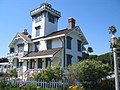
The Point Fermin lighthouse, built in 1874, is one of the oldest buildings in San Pedro

See also
Web links
- Los Angeles Department of City Planning: Community plan Areas (English)
- Website of the municipality of San Pedro (English)
Individual evidence
- ↑ Map of the various districts of Los Angeles (PDF file; 971 kB)
- ^ Website of the Cabrillo Marine Aquarium