San Pedro Sacatepéquez (San Marcos)
| San Pedro Sacatepéquez | ||
|---|---|---|
|
Coordinates: 14 ° 58 ′ N , 91 ° 47 ′ W San Pedro Sacatepéquez on the map of Guatemala
|
||
| Basic data | ||
| Country | Guatemala | |
| Department | San Marcos | |
| - in the metropolitan area | 67,075 | |
| Detailed data | ||
| height | 2330 m | |
| Post Code | 12002 | |
| Time zone | UTC −6 | |
| City patron | Peter and Paul | |
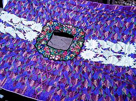
| Shirt throw ( guipil ), San Pedro Sacatepequez | ||
San Pedro Sacatepéquez is a city and a municipality in the department of San Marcos in western Guatemala . The neighboring city of San Marcos joins immediately to the west; both cities are main towns of the homonymous municipality.
Toponym
As with many places in Central America, the name of the city consists of a Spanish colonial part ( San Pedro ) and an Indian part in the Nahuatl language ( sacat = "grass" and tepet = "hill, mountain").
location
San Pedro Sacatepéquez is located at an altitude of about 2330 m in the Valle de Candacuchex (German: "cold place") and is about 240 kilometers (driving distance) from the capital Guatemala City further east . The city of Quetzaltenango is about 50 kilometers to the east.
economy
San Pedro and San Marcos are located on an old trade route to and from Chiapas and Mexico . On the one hand, they still benefit economically from through traffic, on the other hand, the proximity of the Mexican-Guatemalan border also creates problems due to drug and people smuggling.
In the agricultural villages in the area, mainly maize, wheat, potatoes and vegetables are grown. In the city's markets, only locally made, colorfully embroidered wrap skirts ( cortes ) and throws / shirts ( guipiles ) are offered by women .
history
In 1533, by order of Pedro de Alvarado , Juan de León y Cardona subjugated the Mam Indians living in the Candacuchex Valley . After independence from Spain it belonged together with the whole west to the Estado de Los Altos , the so-called sixth state of the Central American Confederation . At the end of the 19th century, the Guatemalan government tried to end the rivalry between San Marcos and San Pedro Sacatepéquez by amalgamating the city of La Unión by decree . The union only lasted until 1945. The two cities, each of which is the administrative seat of two different Municipios, are separated by a wide avenue. San Marcos became a bishopric in 1950; but the former suburb of San Pedro is now a little bigger than San Marcos.
On November 7, 2012 (10:32 am) a light earthquake was felt in the entire San Marcos department; in the village of Concepción Chiquirichapa, eight people were killed in a landslide . The impact and damage in San Pedro Sacatepequez remained minor (see web link for video).
Attractions
Like San Marcos, San Pedro Sacatepéquez has no special sights. The (allegedly) oldest bell in Central America is kept inside the church of the village - it dates from 1577, is almost a meter high and weighs around 500 kg. Both places are suitable as starting points for hiking tours in the mountainous landscape of the Tajumulco and Tacaná volcanoes, about 20 kilometers to the west .
Holidays
- San Pedro y San Pablo (June 29)
See also
Web links
- San Pedro Sacatepéquez - Photos + Info (Spanish)
- San Pedro Sacatepéquez - Photos + Info (Spanish)
- Earthquake in San Pedro Sacatepéquez - Video (Spanish)

