Sankt Erhard (municipality of Breitenau)
|
Sankt Erhard ( Rotte ) locality |
||
|---|---|---|
|
|
||
| Basic data | ||
| Pole. District , state | Bruck-Mürzzuschlag (BM), Styria | |
| Judicial district | Bruck an der Mur | |
| Pole. local community | Breitenau am Hochlantsch | |
| Coordinates | 47 ° 23 '10 " N , 15 ° 27' 16" E | |
| height | 658 m above sea level A. | |
| Residents of the village | 543 (January 1, 2020) | |
| Statistical identification | ||
| Locality code | 14350 | |
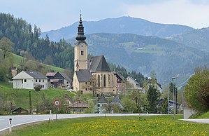
 View of St. Erhard |
||
| Source: STAT : index of places ; BEV : GEONAM ; GIS-Stmk | ||
Sankt Erhard is a village in the municipality of Breitenau am Hochlantsch in Styria. It has 543 inhabitants (January 1, 2020).
geography
Sankt Erhard is located east of Sankt Jakob-Breitenau in the Breitenau, the valley of the Breitenau brook . The Breitenau has been characterized by mining for over 1000 years, from the 11th century onwards, various precious metals such as gold, silver and galena were mined here . The village of St. Erhard is the ecclesiastical center of the community and has a nationally known pilgrimage church, the parish church of Sankt Erhard in the Breitenau . In the 16th century, several hammer mills and scythe hammers were built in the valley. Between 1840 and 1873 the Breitenau iron union also operated its own blast furnace here.
Individual evidence
- ↑ Statistics Austria: Population on January 1st, 2020 by locality (area status on January 1st, 2020) , ( CSV )
- ↑ Interesting facts on Breitenau-hochlantsch
