Sant Pere de Ribes
| Municipality of Sant Pere de Ribes | ||
|---|---|---|
| coat of arms | Map of Spain | |

|
|
|
| Basic data | ||
| Autonomous Community : | Catalonia | |
| Province : | Barcelona | |
| Comarca : | Garraf | |
| Coordinates | 41 ° 16 ′ N , 1 ° 46 ′ E | |
| Height : | 44 msnm | |
| Area : | 40.88 km² | |
| Residents : | 30,719 (Jan 1, 2019) | |
| Population density : | 751.44 inhabitants / km² | |
| Postal code : | 08810 | |
| Municipality number ( INE ): | 08231 | |
| administration | ||
| Official language : | Castilian , Catalan | |
| Mayor : | Josep Antoni Blanco i Abad | |
| Website : | www.santperederibes.org | |
| Location of the municipality | ||

|
||
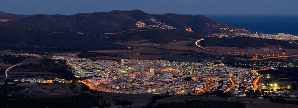
Sant Pere de Ribes is a Catalan city in the province of Barcelona in northeastern Spain . It is located in the center of the Comarca Garraf . In the eastern and northern parts of the village are the foothills of the Garraf mountains ( nature park ). The highest point here is the Montgròs at 359 m. The south and west forms an agricultural plain with rolling hills. in the southwest, between the cities of Sitges and Vilanova i la Geltrú, there is also a 658 m long entrance to the Mediterranean Sea .
Town twinning
Web links
Commons : Sant Pere de Ribes - Collection of images, videos and audio files
Individual evidence
- ↑ Cifras oficiales de población resultantes de la revisión del Padrón municipal a 1 de enero . Population statistics from the Instituto Nacional de Estadística (population update).

