Santiago Tilantongo
| Santiago Tilantongo | ||
|---|---|---|
|
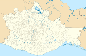
Coordinates: 17 ° 17 ′ N , 97 ° 20 ′ W Santiago Tilantongo on the map of Oaxaca
|
||
| Basic data | ||
| Country | Mexico | |
| State | Oaxaca | |
| Municipio | Santiago Tilantongo | |
| Residents | 474 (2010) | |
| Detailed data | ||
| surface | 1.92 km 2 | |
| Population density | 247 inhabitants / km 2 | |
| height | 2200 m | |
| Tilantongo - picture glyph in Codex Nuttall | ||
| Ruler 8 Deer Jaguar Claw (right) | ||
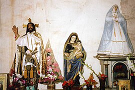
| Tilantongo - figure group during Holy Week | ||
Santiago Tilantongo (short: Tilantongo ) is a village with about 500 inhabitants in the northwest of the state of Oaxaca in Mexico ; In addition, it is the administrative seat of the municipality of the same name (municipio), which has a total of around 3,200 inhabitants . Tilantongo was once under its original name Nuu Tnoo the capital of Mixtekenreichs .
Location and climate
Tilantongo is located at an altitude of about 2200 m in the Nochixtlán district, which also includes Santo Domingo Yanhuitlán and Santa María Apazco , in the mountainous region of Mixteca Alta . The distance to Asunción Nochixtlán is almost 35 km (driving distance) in a north-easterly direction; the city of Oaxaca de Juarez is approx. 120 km to the southeast. The climate is temperate to warm; Rain (approx. 530 mm / year) falls mainly in the summer months.
Population development
| year | 2000 | 2005 | 2010 |
| Residents | 395 | 496 | 474 |
The inhabitants are without exception of Mixtec descent; one speaks mainly Mixtec dialects.
economy
Already in pre-Hispanic times, the area was of Mixtecs settled -Indianern. The people of the region still live largely self-sufficient from the yields of their fields (corn, wheat) and gardens (potatoes, beans, tomatoes, chilli, etc.). Cattle breeding is only practiced to a limited extent (chickens, turkeys). Hats, bags, etc. are made from small Jipijapa palms.
history
Around 600 AD a place of worship was built on the nearby Monte Negro mountain ; this became larger and more important in the 11th century. Under the ruler 8-Hirsch-Jaguarkralle (* 1063) and his successors, the place became the political, economic and cultural center of an empire that encompassed the entire mountain region and the coastal plain of the Mixteca . In the 15th century the Aztecs and their allies faced increasing expansion efforts; in the 16th century the Spanish conquistadors and missionaries came .
Attractions
- The excavation site on Cerro Negro , which was explored in the 1960s, is of little interest.
- In the unadorned church, which was built in the 16th or 17th century, there are numerous figures of saints, which are carried in processions on special feast days.
literature
- Ronald Spores: The Mixtec Kings and Their People. University of Oklahoma Press 1967, ISBN 0-8061-1091-0 .
Web links
- Santiago Tilantongo - Info (INAFED, Spanish)


