Santiago Tuxtla
| Santiago Tuxtla | ||
|---|---|---|
|
Coordinates: 18 ° 28 ′ N , 95 ° 18 ′ W Santiago Tuxtla on the map of Veracruz
|
||
| Basic data | ||
| Country | Mexico | |
| State | Veracruz | |
| Municipio | Santiago Tuxtla | |
| City foundation | 1525 | |
| Residents | 15,459 (2010) | |
| City insignia | ||
| Detailed data | ||
| height | 212 m | |
| Santiago Tuxtla - Parque Juarez with town hall tower (center) and church towers (left) | ||
| Colossal Olmec head in the main square | ||
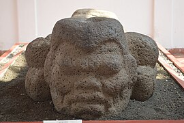
| Sacrificial altar with negroid-looking head in the Museo Regional Tuxteco | ||
Santiago Tuxtla is a city in the southeast of the Mexican state of Veracruz . Santiago Tuxtla is the administrative seat of the Municipio Santiago Tuxtla and has about 15,000 inhabitants.
geography
- location
Santiago Tuxtla is located in the northwestern foothills of the Sierra de los Tuxtlas about 30 kilometers from the Mexican Gulf coast at an altitude of about 200 m above sea level. d. M. The city is just under 520 kilometers to the south-east of Mexico City ; Veracruz , the former capital of the state, is a good 140 kilometers to the northwest.
- geology
The soils in the region are mostly of volcanic origin, although the El Vigía volcano is considered extinct. For thousands of years volcanic activity has shifted further northwest into the Sierra Volcánica Transversal .
- climate
The annual average temperatures are around 24 to 26 ° C with a rainfall that can fluctuate between 1400 and 3600 mm annually. The humidity is usually correspondingly high.
population
The city of Santiago Tuxtla has around 15,000 inhabitants. About 90% of the population are Catholic.
economy
While the population in the surrounding area lives mainly from agriculture (corn, sugar cane, beans, etc.) and from cattle breeding (cattle, pigs, turkeys), the city is the artisanal, mercantile and cultural center of the region. In the last few decades the service sector (banks, insurance companies, tourism, etc.) has experienced a significant boom, but by Mexican standards the region is considered to be rather backward and poor.
history
Human settlements go back a long way in the humid hot, but in combination with the mineral-rich soils, very fertile region. With the Olmecs , one of the first and at the same time most important advanced civilizations in Mesoamerica came into being , from which impulses for the construction of temple pyramids came as well as for the development of sculpture and the calendar . The place of worship Tres Zapotes is one of the longest continuously inhabited places in Mexico. The Spanish conquistadors came to this area around 1520, but the city, named after the apostle James , was only founded in 1525. It belonged to the conqueror Hernán Cortés, who was appointed Marqués del Valle de Oaxaca in 1529 .
Attractions
- The Parque Juarez , where the Palacio Municipal is also located, is located in the center of the city and is used by the population - especially in the evenings - to stroll and promenade. The largest Olmec colossal head found so far was also erected here, with a height of approx. 3.40 m and a weight of approx. 38 tons; he comes from Rancho la Cobáta near Tres Zapotes .
- In the centrally located Museo Regional Tuxteco you can see the monumental head Q, which was transported here from Tres Zapotes , but with its height of about 1.50 m it is significantly smaller than the one on the plaza. There are also other artifacts from Tres Zapotes and other less significant sites.
- The elongated church of the town, built in the 19th century with its two unequal high facade towers, is dedicated to St. Consecrated to James .
Web links
- Santiago Tuxtla . Website - Photo + Quick Info (Spanish)
- Santiago Tuxtla . Website - photo + brief information (Spanish)
- Santiago Tuxtla, Olmec monumental head from Rancho de la Cobáta. photos
- Santiago Tuxtla, Museo Regional de Tuxtla Photos + brief information (Spanish)
- Santiago Tuxtla, Olmec monumental head from Tres Zapotes. photos
- Enciclopedia de los Municipios y Delegaciones de México: Santiago Tuxtla - Information (Spanish)


