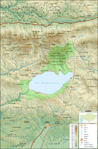
Sarymsaqty
| Sarymsaqty | |
|---|---|
|
Sarymsaqty mountain range north of Lake Markakol -Sees |
|
| Highest peak | Burkitaul ( 3373 m ) |
| location | East Kazakhstan ( Kazakhstan ) |
| part of | Altai Mountains |
| Coordinates | 49 ° 4 ′ N , 85 ° 27 ′ E |
The Sarymsaqty ( Kazakh Сарымсақты жотасы ; Russian Сарымсакты, Сарым-Сакты Sarymsakty ) is a mountain in the southern Altai in the area Eastern Kazakhstan .
The Sarymsaqty runs north of the Markakol lake over a length of 60 km in an east-west direction. The Buchtarma river valley runs north . The Kürschim drains the southwest flank to the Buchtarma reservoir . To the west the mountain range is continued through the lower Naryn ridge . In the south-west the Sarymsaqty merges into the Kürschim ridge . The Sarymsaqty reaches its maximum height in Burkitaul with 3373 m . There is a very small area of glaciers (about 1 km²) in the mountain range.
Individual evidence
- ↑ a b Article Sarymsaqty in the Great Soviet Encyclopedia (BSE) , 3rd edition 1969–1978 (Russian)

