
Sawran (river)
|
Sawran Savran |
||
 Sawran near Sawran |
||
| Data | ||
| location | Ukraine | |
| River system | Southern bow | |
| Drain over | Southern Bug → Black Sea | |
| source | Podolian plate near Rudnyzke | |
| muzzle | at Sawran in the South Bug Coordinates: 48 ° 8 ′ 26 ″ N , 30 ° 6 ′ 10 ″ E 48 ° 8 ′ 26 ″ N , 30 ° 6 ′ 10 ″ E
|
|
| length | 97 km | |
| Catchment area | 1770 km² | |
| Left tributaries | Jalanez , Rohiska | |
| Right tributaries | Mala Sawranka , Smolyanka | |
| Small towns | Chechelnyk | |
| Communities | Pishchana , Olhopil | |
The Sawran ( Ukrainian Саврань , also Sawranka (Ukrainian Савра́нка )) is a right tributary of the Southern Bug in Ukraine .
The Sawran has a length of 97 km and a catchment area of 1770 km². Its source is located on the Podolian Plate on the western edge of the village of Rudnyzke ( Рудницьке ) in Pishchanka district of Vinnytsia Oblast . The river then flows through Chechelnyk Raion and Balta Raion and flows into the Southern Bug from the right in the Sawran Raion of Odessa Oblast , in the northeast of the urban-type settlement Sawran .
There are three dams on Sawran that dam small lakes. The river is used to supply drinking water, as well as for irrigation and fish farming.
Tributaries are, besides some nameless tributaries:
- from the left:
- from the right:
- Mala Sawranka ( Мала Савранка ) 46 km in length
- Smoljanka ( Смолянка ) 60 km in length

Pond near Rudnyzke
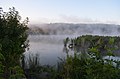
Lake at Horodyschtsche ( Городище )

River bank at Horodyschtsche
_04.JPG)

_02.JPG)
Web links
Individual evidence
- ↑ Entry on Sawran in the Ukrainian Soviet Encyclopedia ; accessed on March 27, 2018 (Ukrainian)
- ↑ river Sawran on mapexpert.com.ua ; accessed on March 27, 2018 (Ukrainian)