
Saxuirer Feuerkogel
| Saxuirer Feuerkogel | ||
|---|---|---|
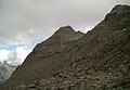
 Saxuirer Feuerkogel from the Aherkogel (from the northwest) |
||
| height | 2806 m above sea level A. | |
| location | Tyrol , Austria | |
| Mountains | Ötztal Alps | |
| Dominance | 0.61 km → Middle Stupfarri | |
| Notch height | 71 m ↓ notch to the Stupfarri | |
| Coordinates | 47 ° 4 '38 " N , 10 ° 47' 51" E | |
|
||
| First ascent | Unknown | |
| Normal way | North ridge ( I ) | |

The Saxuirer Feuerkogel ( 2806 m above sea level ) is a mountain of the front Kaunergrat , a mountain range of the Ötztal Alps . The summit structure of the mountain is formed by a pyramid made of reddish stone, which also makes the name seem plausible ("Feuerkogel"). The Saxuirer Feuerkogel is the highest elevation of a side ridge that begins at the central stuparri and descends to the southeast in the direction of the valley. A small lake basin lies directly under the pyramid-shaped summit structure of the mountain. From the summit you have an excellent view of the mountains of the front Geigenkamm and the mountains around the Rofelewand . The mountain is not mentioned in the Alpine Club Guide .
Routes
Normal route : From the Neubergalm or the Mauchelealm on the Almenweg into the Saxuire Valley, through which the Saxuire Bach flows. Now over steep meadow slopes, later over rubble up to the west up the valley. You climb up to the block fields north of the mountain. You now climb over blocks, some of which are meter-sized, in the direction of the Seemulde, pass a steep rocky zone and reach the lake. Now along the edge of the railing to the ridge. Always on the ridge with small bypasses in easy climbing ( I ) to a flat ridge narrowing, via which you can reach the summit.
photos
Feuerkogel from the Saxuire Valley

Seemulde and Feuerkogel

Connection ridge to the middle stuparri


map
- Alpine club map sheet 30/3, 1: 25,000, Ötztal Alps, Kaunergrat . ISBN 978-3-928777-41-4