
Schönsteiner Bach
|
Schönsteiner Bach upper course: Kriegbach |
||
 Schönsteiner Bach south of Weihermühl |
||
| Data | ||
| Water code | DE : 15814 | |
| location | District of Straubing-Bogen | |
| River system | Danube | |
| Drain over | Kinsach → Danube → Black Sea | |
| source | for Zinzenzell 49 ° 4 ′ 35 " N , 12 ° 34 ′ 59" E |
|
| Source height | approx. 635 m | |
| muzzle | at Irlmühl in the Kinsach coordinates: 49 ° 3 '55 " N , 12 ° 38' 6" E 49 ° 3 '55 " N , 12 ° 38' 6" E |
|
| Mouth height | approx. 375 m | |
| Height difference | approx. 260 m | |
| Bottom slope | approx. 51 ‰ | |
| length | 5.1 km | |
| Catchment area | 6.32 km² | |
| Communities | Wiesenfelden , Stallwang | |
The Schönsteiner Bach is an approximately 5 km long brook in the Straubing-Bogen district in Lower Bavaria , which flows into the Kinsach from the right and west near Irlmühl in the Stallwang municipality .
course
The source area is on the edge of the parish village of Zinzenzell , which is part of the municipality of Wiesenfelden . There the Schönsteiner Bach is also called the Kriegbach . After exactly three kilometers, mostly south-easterly at the edge of the forest, he reaches Schönstein , the eponymous church village in the area of the municipality of Stallwang. After another two kilometers in an easterly direction, the Schönsteiner Bach flows into the Kinsach near Irlmühl in the municipality.
From Weihermühl the road from Hötzelsdorf to Schönstein runs about half a kilometer through the valley, at Roßberg it is crossed by another from Maiszell to Reichersdorf, from where the SR 46 district road enters the lowest valley and in it a little over half a kilometer to the Muzzle runs. Otherwise, and especially on the entire upper reaches, the valley is free of roads.
Localities
- on the run from the source to the mouth. Only the entries with the greatest nesting depth are bordering waters.
- Community Wiesenfelden
- Zinzenzell (parish village, neighboring spring)
- Stallwang municipality
- Weihermühl (hamlet, mostly on the left)
- Hagmühl (wasteland, left)
- Schönstein (Kirchdorf, left slope)
- Roßberg (wasteland, left)
- Irlmühl (wasteland, on the right already in Kinsach-Aue)
history
In a description from 1829 it is referred to as Grabenbächl , which has a total of three mills, one of them in Roßberg and two in Schönstein.
gallery

Schönsteiner Bach south of the sports facility in Zinzenzell

Schönsteiner Bach south of the sports facility in Zinzenzell
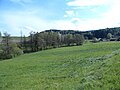
Schönsteiner Bach south of Weihermühl

Schönsteiner Bach south of Weihermühl


Web links
Individual evidence
- ↑ Bavaria Atlas - map of the headwaters
- ↑ Bavaria Atlas - Map of the estuary
- ↑ a b Directory of the stream and river areas in Bavaria - Naab to Isar river area, page 93 of the Bavarian State Office for the Environment, as of 2016 (PDF; 2.8 MB)
- ^ Repertory of the topographical atlas sheet .... [49], Mitterfels . Munich 1829, p. 85 , urn : nbn: de: bvb: 12-bsb10944957-0 ( digitized - "Grabenbächl, arises near Zinzenzell, flows east, and merges with the Kiensachbach at Irlmühle.").