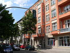
Schustehrusstrasse
| Schustehrusstrasse | |
|---|---|
| Street in Berlin | |
| Basic data | |
| place | Berlin |
| District | Charlottenburg |
| Created | in the 17th century |
| Hist. Names | Deichweg, Scharrenstrasse |
| Connecting roads | New Christ Street (west) |
| Cross streets |
Schlossstrasse , Nithackstrasse , Kaiser-Friedrich-Strasse , Gierkezeile , Wilmersdorfer Strasse , Richard-Wagner-Strasse |
| Places | Greed place |
| use | |
| User groups | Road traffic , pedestrians |
| Technical specifications | |
| Street length | 420 meters |
The Schustehrusstraße is a street in the district of Charlottenburg in the district of Charlottenburg-Wilmersdorf of Berlin . It runs in an east-west direction from Schloßstraße over Gierkeplatz with the Luisenkirche to Richard-Wagner-Platz and Otto-Suhr-Allee .
history

The north direction is on the right. On the right also the castle and the Spree, the Schloßstraße horizontal, today's Otto-Suhr-Allee diagonal. Between the two from top to bottom across the circular squares, Schustehrusstrasse. The "wet triangle" meant here to the left of Gierkeplatz with the cross-shaped Luisenkirche; the black ditch also drawn.
On old plans the street is called Deichstraße or Teichstraße . The name, probably first documented in 1711, refers to the carp pond , which was created in 1711 on the wetland of today's Nassen Dreieck on Hebbelstrasse by damming the Black Trench . The carp pond itself was probably the namesake. The street was initially the only connection between the two halves of Charlottenburg, which were divided by the Black Ditch. The part of the street east of the church was called Scharrenstrasse since 1724 at the latest . Scharren was the name of the vending cart of the dealers who sold their products here. Since 1824 at the latest, the western part was also called Scharrenstrasse. The street was given its current name in 1950, after the former mayor of Charlottenburg, Kurt Schustehrus (1856–1913).
Oldest street in Charlottenburg?
In their book Berlin around 1700. The ideal city of Charlottenburg , the authors Prösel and Kremin try to prove that Schustehrusstraße is the oldest street in Charlottenburg. They refer to two maps, one of them from 1698, both of which show a path that leads in a straight line from a collection of houses on today's Richard-Wagner-Platz to a crossing of the Black Trench. They speculate that this street was laid out for the construction of the Charlottenburg Palace in 1695. Schloßstraße, which other authors claim to be the oldest street in Charlottenburg, is not shown on these maps. However, according to the plans, today's Otto-Suhr-Allee also seems to be considered as the oldest street. In 1706 , Eosander von Göthe included the straight course of the forerunner path of Schustehrusstraße shown on the maps in his plan for the city of Charlottenburg.
Development
The Oppenheim School is located on the south side of Schustehrusstraße in a building adjacent to Villa Oppenheim . Next to it on the east side is the Schustehruspark .
About in the middle of Schustehrusstraße, at the intersection with Gierkezeile, is the Protestant Luisenkirche on Gierkeplatz. In the immediate vicinity, on the site of the community hall of the Luisengemeinde, was the house of the parish priest and Charlottenburg chronicler Johann Christian Gottfried Dressel . A memorial plaque reminds of him here.
The house at number 13 is the oldest surviving Charlottenburg residential building. It was built in 1712 after the model of the house of the Chamberlain Hassan, formerly located at Schloßstraße 6, which was specified as a binding model in the context of the development plan Eosander von Göthes in the interest of a uniform cityscape. The Berlin Ceramic Museum has its place in it today . The house is a listed building . A total of thirteen buildings on this street are included in the Berlin list of monuments.
See also
literature
- Henrike Hülsbergen (ed.): Charlottenburg really is a city - from the unpublished chronicles of Johann Christian Gottfried Dressel (1751–1824). Edition Divan, Berlin 1987, ISBN 3-925683-04-6 .
- Susan Prösel, Michael Kremin: Berlin around 1700. The ideal city of Charlottenburg. Ed .: Technical University of Berlin , d. President. Publica Verlagsgesellschaft, Berlin 1984, ISBN 3-89087-008-2 .
Web links
- Schustehrusstrasse. In: Street name lexicon of the Luisenstädtischer Bildungsverein (near Kaupert )
Individual evidence
- ↑ The Luisenstädtischer Bildungsverein assumed that the origin was “dykes raised in 1711 in the carp pond meadows”: Deichstrasse . In: District lexicon of the Luisenstädtischer Bildungsverein.
- ↑ Situation map of the city of Charlottenburg from 1724 in: Sonja Miltenberger: Charlottenburg in historical maps and plans , Jaron, Berlin 1998, ISBN 3-932202-32-5 , p. 25. There the carp pond is called Der Karpfen Deich .
- ↑ Scharrenstrasse . In: Street name lexicon of the Luisenstädtischer Bildungsverein
- ↑ Prösel, Kremin: The Ideal City Charlottenburg . Berlin 1984, p. 15f
- ^ Dresselstrasse. In: Street name lexicon of the Luisenstädtischer Bildungsverein (near Kaupert )
- ↑ Schustehrusstraße 13, residential building, 1712; Remodeled 1877–78 by Ernst George; Restoration 1984-94


