Schwarzmühlenteich
| Schwarzmühlenteich | ||
|---|---|---|

|
||
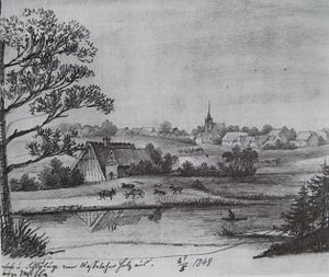
| Schwarzmühlenteich 1848 | ||
| Geographical location | Lübeck , Schleswig-Holstein and Lüdersdorf , Mecklenburg-Western Pomerania | |
| Drain | Landgraben (Schlutuper Bach, Schwarzmühlenbach) | |
| Places on the shore | Lübeck | |
| Data | ||
| Coordinates | 53 ° 52 '31 " N , 10 ° 47' 27" E | |
|
|
||
| surface | 2.9 ha | |
| length | 310 m | |
| width | 180 m | |
The Schwarzmühlenteich is a mill pond south of the Schlutup district of Lübeck , which was dammed in 1619 to operate a fulling mill . The state border between Schleswig-Holstein and Mecklenburg-Western Pomerania runs through it . The northwestern part of the water area is in the city of Lübeck, the southeastern part within the municipality of Lüdersdorf .
Geography and nature
The 2.9 hectare body of water has maximum dimensions of about 310 by 180 meters. The water level is less than ten meters above sea level. From the west, a peninsula in the silting area and in the areas of both countries protrudes into the pond, which is overgrown with deciduous trees. The water flows over the Landgraben to the west to the Wakenitz , this section is also called Schlutuper Bach, and to the north over the ditch, also called Schwarzmühlenbach, to the Trave in this section . The outflow to the north is piped in the area of a courtyard crossing. To the south, on the Mecklenburg-Western Pomerania side, there is a larger forest area, through which the federal road 104 runs close to the shore on the border strip of the former inner German border . Loose residential and commercial buildings are adjacent to the Lübeck riverside. A residential area belonging to the Schlutup district begins about 150 meters to the northeast.
The Schleswig Holstein part of Black mill pond is complete within about 170 hectares protected landscape Schlutup .
Typical features of silting vegetation can be found through aquatic plants, swinging lawns and reed belts. The area is characterized by broken forest, buildings and wet grassland. Impairments are seen through pasture use and the associated representation on the northern bank as well as fishing.
history
The Schwarzmühlenteich was dammed in 1619, at the time of the up-and-coming drapery trade, at the Landgraben to operate a fulling mill . Originally it was a natural lake in a hollow without any drainage. The mill was initially left to the head of the St. Anne's monastery , from 1670 it was available to the office of the Raschmacher . The city of Lübeck, the owner, leased this watermill , which was used to crush rags, as well as the Schlutuper Mühle (at Schlutuper Mühlenteich ), where paper was made, only together from 1715, since the water from the Schwarzmühlenteich is also important for the Schlutuper watermill and this was the only way to avoid the constant quarrel between the two mill operators. After ceasing operations in 1798, the Schwarzmühle was demolished in 1816.
During the Wars of Liberation , on August 22, 1813, there was an attack at the Schwarzen Mühle between the outpost of the French occupation of Lübeck, Danish dragoons, and attacking Mecklenburg volunteer hunters who were part of the Northern Army under Swedish command.
The former location of the mill is presumed to be on the site of a farm that is located there today. Today only the pond is evidence of the former mill.
literature
- Rudolf MG Thormann: Mills around Lübeck - water and windmills from the 13th to the 19th century Part 1, Lübeck 1993, pp. 67-76. ISBN 3-7950-1207-4
Individual evidence
- ↑ Landscape plan of the Hanseatic City of Lübeck - surface waters (map, PDF file) ( page no longer available , search in web archives ) Info: The link was automatically marked as defective. Please check the link according to the instructions and then remove this notice.
- ↑ "Schlutup" nature reserve on travemuende.de
- ↑ a b Landscape plan of the Hanseatic city of Lübeck ( page no longer available , search in web archives ) Info: The link was automatically marked as defective. Please check the link according to the instructions and then remove this notice. (PDF file)
- ^ Hugo von Boddien: The Mecklenburgische Freiwilligen-Jäger-Regiments: Memories from the years 1813 and 1814. Rostock: Hinstorff 1863 ( digitized version ), p. 85
- ↑ Historical cultural landscapes in Lübeck - Schwarzmühlenteich ( page no longer available , search in web archives ) Info: The link was automatically marked as defective. Please check the link according to the instructions and then remove this notice. (PDF file; 986 kB)
