Hominde lake barrier
Coordinates: 54 ° 42 ′ 18 ″ N , 11 ° 15 ′ 0 ″ E
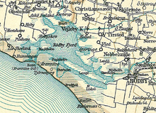
The Hominde lake barrier ( Danish Homindespærringen ) near Rødby , on the south coast of the Danish island of Lolland , was discovered in 1930 and has been made accessible since 1994 through systematic studies by underwater archaeologists.
location
The south coast of Lolland was last devastated by a storm surge in 1872 ; today's coastal landscape was created through land reclamation and was associated with the drainage of the Rødby Fjord . In the Viking Age (800-1050 AD), the Rødby Fjord was a frequent target of attacks and raids carried out from the sea. The attackers used the fjord as a gateway into the hinterland .
description
The Hominde Maritime Barrier formed a hidden obstacle in the fjord's fairway; it consisted of a pile structure (mainly oak ) about 200 m long and 10 m wide rammed into the ground in an arc shape . There was a narrow opening, the location of which was known only to the initiated. The barrage, built on an area of around 1600 m², was started according to C14 dating around the year 1020 (± 100 cal) (reign of Sven Gabelbart ). The 1994 investigation revealed that the lake barrier had existed for a long time and had since been rebuilt. In its classic form, with horizontal front barriers, it dates from around 1140, i.e. from the reign of King Erik III. Lam , who ruled until 1146, or his successors, including Waldemar I , who pursued an active policy of expansion in the Baltic Sea.
meaning
Since 1993, the National Museum of Denmark has carried out a systematic study of medieval underwater defense structures that blocked bays and fjord mouths. According to Anne Nørgaard Jørgensen , these types of defenses were an effective way of protecting the people of the Danish islands from raids. In the coastal waters of Denmark, both sea barriers based on the example of Hominde and ropes and chains “built into” rivers were used. With the sea barriers, the social structure within the island population was consolidated, it was a basis for the emergence of a Danish state.
The sea barrier now served to ward off attacks by the Slavs . An at least selective settlement of the islands of Lolland and Falster , which took place between 900 and 1300, is evidenced by Slavic place names (such as Korselitse, Kramnitse, Tillitse), which FW Housted researched. A few years after Erik III. the Danish king Waldemar I conquered the island of Rügen and ended the Slavic threat. His grave slab reports that the Slavs ravaged Denmark before he took office.
See also
literature
- Anne Nørgaard Jørgensen: Homindespærringen . In: Lolland-Falsters Historiske Samfund (ed.): Lolland-Falsters Historiske Samfunds årbok . 1996, ISSN 0107-8798 , p. 19-36 .
- Anne Nørgaard Jørgensen: The Hominde barrage on Lolland - new investigations. (Homindespærringen på Lolland - nye undersøgelser) . In: Maritime Archeology Newsletter from Roskilde . tape 7 . Roskilde 1996, p. 7-11 .
- Reallexikon der Germanischen Altertumskunde , Volume 29, p. 343 ( online )
- Karen Løkegaard Poulsen: Slavic elements in the archaeological sources of Lolland and Falsters . In: Ole Harck, Christian Lübke (ed.): Between Reric and Bornhöved: The relations between the Danes and their Slavic neighbors from the 9th to the 13th century. Contributions to an international conference, Leipzig 4.-6. December 1997 . Steiner, Stuttgart 2001, ISBN 3-515-07671-9 , p. 102 f. ( online )
Individual evidence
- ↑ a b Offshore Defense Structures in Denmark, 200–1300 . In: Château Gailland (ed.): Etudes de Castellogie Medievale . tape 18 . Brepols Publishers, 1998, pp. 149-151 .
- ↑ Arkæologiske udgravninger i Danmark. (PDF; 569 kB) Danish monument protection authority (cultural archive), 1994, accessed on February 25, 2011 (Danish): “221. Hominde: Supplerende undersøgelse af søspærring, the dækker et areal on 1,600 m². En række constructional details blev belyst, bl.a. At the mange tusinde nedrammede egepæle on the dybeste sted i Vestre Skarholmsrenden kunne udgøre et op til 10 m bredt bælte, men ved landfæstet blot 1 m. En C-14 catering har givet en catering to 1020 AD ± 100 cal "
- ^ Karen Løkkegaard Poulsen: Slavic elements in the archaeological sources of Lolland and Falsters. In: Ole Hark and Christian Lübke (eds.): Between Reric and Bornhöved: the relations between the Danes and their Slavic neighbors from the 9th to the 13th century. Contributions to an international conference, Leipzig December 4-6, 1997. pp. 79-106, Franz Steiner Verlag, Stuttgart 2001, pp. 102 f. ISBN 3-515-07671-9 ( online )
- ↑ Sejlspærringen ved Hominde. Lolland-Falster Stiftsmuseum, September 11, 2001, archived from the original on June 13, 2007 ; Retrieved on February 25, 2011 (Danish, adult education event on marine archeology under the direction of Anne Nørgaard Jørgensen ): “Sejlspærringen ved Hominde and organiseringen af kystforsvaret i yngre jernalder, vikingetid and tidlig middelalder. Ved ph.d. Anne Nørgård Jørgensen, National Museum. "
- ↑ Wendish (Slavic) place names on Lolland and Falster by Leif Plith Lauritsen: https://d-nb.info/987704427/04


