
Daun-Senheld glider airfield
| Daun-Senheld glider airfield | |||
|---|---|---|---|
|
|||
| Characteristics | |||
| Coordinates | |||
| Height above MSL | 525 m (1722 ft ) | ||
| Transport links | |||
| Distance from the city center | 4 km southwest of Daun | ||
| Street | available | ||
| train | 20 km | ||
| Local transport | 4 km | ||
| Basic data | |||
| opening | 1957 | ||
| operator | Segelflugverein Vulkaneifel eV | ||
| Start-and runway | |||
| 09/27 | 482 m × 15 m asphalt | ||

The Daun-Senheld glider airfield is located on a ridge directly between two Eifel maars in the municipality of Mehren in the Vulkaneifel district in Rhineland-Palatinate .
history
In the 1930s there was already a gliding school on Radersberg near Daun , which was closed after the war ended in 1945. In 1957, an aeroclub was founded by regional pilots and a glider flight area was set up on the Senheld, which is now operated by the glider club Vulkaneifel eV. The place was gradually expanded. In 1977 the slope was paved. After only winch starts were initially possible, there was also the possibility of a tow start.
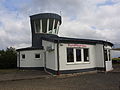
Tower of the square
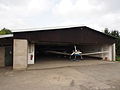
hangar


Place data
The place is approved for gliders , UL aircraft , self- launching motor gliders and aircraft that are approved for the purpose of towing gliders or motor gliders. It is possible to refuel.