Setmurthy
| Setmurthy | ||
|---|---|---|
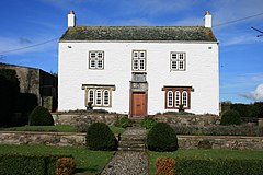
| Hewthwaite Hall | ||
| Coordinates | 54 ° 41 ′ N , 3 ° 16 ′ W | |
|
|
||
| Residents | 110 (as of 2011) | |
| administration | ||
| Post town | Cockermouth | |
| ZIP code section | CA13 | |
| prefix | 017687 | |
| Part of the country | England | |
| region | North West England | |
| Shire county | Cumbria | |
| District | Allerdale | |
| Civil Parish | Setmurthy | |
| British Parliament | Copeland | |
Setmurthy is a municipality in the Borough of Allerdale the county of Cumbria in England .
geography
The administrative unit is located in the Lake District between Cockermouth and Keswick . Neighboring towns are Blindcrake and Sunderland in the north, Bewaldeth in the northeast, Bassenthwaite in the east, Wythop in the southeast, Embleton in the south, Cockermouth in the southwest, Papcastle in the west and Bridekirk in the northwest.
Buildings
In the municipality there are a total of nine buildings that are registered in the National Heritage List for England. Including Hewthwaite Hall, a farmhouse from 1581. In addition, on the relatively flat Elva Plain, on the southern slopes of the 240 meter high Elva Hill, there is a historical stone circle consisting of 15 granite blocks.
literature
- John Askew: Guide To The Interesting Places In And Around Cockermouth - With An Account Of Its Remarkable Men And Local Traditions . Cockermouth 1872 (English).
Web links
- Setmurthy on cumbriacountyhistory.org.uk (English)
- Setmurthy on visionofbritain.org.uk (English)
- Setmurthy on genuki.org.uk (English)
Individual evidence
- ↑ Parish Profiles - Parish to Ward Population Lookup Table - Census 2011, accessed March 3, 2020.
- ↑ Hewthwaite Hall - National Heritage List for England, accessed March 3, 2020. (English)
- ↑ Large regular stone circle 240m ENE of Elva Plain - National Heritage List for England, accessed March 3, 2020.

