Allerdale
| Borough of Allerdale | |
|---|---|
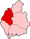
 Location in Cumbria |
|
| status | Borough |
| region | North West England |
| Administration County | Cumbria |
| Administrative headquarters | Workington |
| surface | 1257.79 km² (13.) |
| Residents | 94,500 (239.) |
| ONS code | 16UB |
| Website | allerdale.gov.uk |
| founding | April 1, 1974 |
Allerdale is an administrative district with borough status in Cumbria in England . The administrative seat is the city of Workington ; other important places are Cockermouth , Keswick and Maryport .
history
The district was formed on April 1, 1974 and was created from the merger of Borough Workington, the urban districts Maryport, Cockermouth and Keswick and the rural districts Cockermouth and Wigton. It initially had the status of a district and was given that of a borough in 1995.
cities and communes
Above Derwent , Aikton , Allhallows , Allonby , Aspatria , Bassenthwaite , Bewaldeth and Snittlegarth , Blennerhasset and Torpenhow , Blindbothel , Blindcrake , Bolton , Borrowdale , Bothel and Threapland , Bowness-on-Solway , Bridekirk , Brigham , Bromfield , Broughton , Broughton Moor , Buttermere , Caldbeck , Camerton , Cockermouth , Crosscanonby , Dean , Dearham , Dundraw , Embleton , Gilcrux , Great Clifton , Greysouthen , Hayton and Mealo , Holme Abbey , Holme East Waver , Holme Low , Holme St Cuthbert , Ireby and Uldale , Keswick , Kirkbampton , Kirkbride , Little Clifton , Lorton , Loweswater , Maryport , Oughterside and Allerby , Papcastle , Plumbland , Seaton , Sebergham , Setmurthy , Silloth-on-Solway , St John's Castlerigg and Wythburn , Thursby , Underskiddaw , Waverton , Westnewton , Westward , Wigton , Winscales , Woodside , Workington , Wythop
Other places
Braithwaite , Dubwath , Little Town , Seathwaite , Seatoller
Web links
- Allerdale Borough Council (English)
Individual evidence
- ↑ Local Government Act 1972 , accessed March 4, 2020. (English)
Coordinates: 54 ° 38 ′ N , 3 ° 25 ′ W
