Sherbro (river)
| Sherbro | ||
|
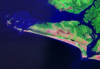
Sherbro Island with the Sherbro to the east |
||
| Data | ||
| location |
|
|
| River system | Sherbro Water Resource Area Jong Basin |
|
| muzzle |
Atlantic Ocean Coordinates: 7 ° 39 ′ 37 " N , 12 ° 34 ′ 41" W 7 ° 39 ′ 37 " N , 12 ° 34 ′ 41" W |
|
| Mouth height |
0 m
|
|
| Catchment area | 10,380 km² | |
The Sherbro (also Sherbo Strait ) is an estuary in Sierra Leone, West Africa . It separates Sherbro Island from the mainland and is the estuary of several rivers.
description
The system of rivers and creeks in the Sherbro Estuary is very complex. The largest rivers and tributaries are the Bagru (Gbangbaia), the Taia (Jong) and the Sewa and Waanje rivers over the Kittam .
The estuary branches have their own names and are differentiated from the main rivers depending on the source. In terms of its location, type and extent, it is more like a bay or strait .
Protected areas
The estuary of the Sherbro is designated as a marine (28,354 hectares ) or forest reserve (10,100 hectares).
Web links
Individual evidence
- ↑ Map 1 Sierra Leone's river basins. Salone Water Security. Retrieved March 2, 2018.
- ^ Maps of the river systems in Sierra Leone
- ^ Sierra Leone. United Nations, Department for Peacekeeping Operations Cartographic Section, 2004.
- ^ Sherbro River Estuary. Protected Planet / IUCN. Retrieved March 2, 2018.
- ↑ CONTENT PROVISION INTO THE COUNTRY YEARBOOK OF SIERRA LEONE 2017 Ministry of Fisheries and Marine Resources. Retrieved March 2, 2018.
- ^ Forest Reserves in Sierra Leone and their Status. In: The Statistical Digest 2007-2013, Statistics Sierra Leone, 2014, p. 296. ( Memento of the original dated February 2, 2017 in the Internet Archive ) Info: The archive link was inserted automatically and has not yet been checked. Please check the original and archive link according to the instructions and then remove this notice.
