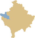
Shtupeq i Vogël
|
Shtupeq i Vogël / Shtupeqi i Vogël 1 Mali Štupelj / Мали Штупељ 2 |
||||
|
||||
| Basic data | ||||
|---|---|---|---|---|
| State : |
|
|||
| District : | Peja | |||
| Municipality : | Peja | |||
| Coordinates : | 42 ° 40 ′ N , 20 ° 13 ′ E | |||
| Residents : | 0 (2011) | |||
| Telephone code : | +383 (0) 39 | |||
| License plate : | 03 | |||
|
1 Albanian (indefinite / definite form) , 2 Serbian (Latin / Cyrillic spelling) 3 Kosovo's independence is controversial. Serbia continues to regard the country as a Serbian province. |
||||
Shtupeq i Vogël ( Albanian also Shtupeqi i Vogël or Shtupeç / ii Vogël , Serbian Мали Штупељ Mali Štupelj ) is a village in western Kosovo in the municipality of Peja . It is located in the Rugova Gorge in the area of the Bjeshkët e Nemuna National Park , which protects parts of the Albanian Alps . The village is located on the northern slope of the valley above the Pećka Bistrica .
According to the 2011 census , Shtupeq i Vogël is uninhabited.
| Census | 1948 | 1953 | 1961 | 1971 | 1981 | 1991 | 2011 |
|---|---|---|---|---|---|---|---|
| Residents | 185 | 130 | 94 | 95 | 38 | 106 | 0 |
Individual evidence
- ↑ Popullsia e komunës së Pejës sipas vendbanimit, gjinisë dhe etnicitetit 2011. In: rks-gov.net. Statistics Agency of Kosovo, accessed on May 31, 2017 (Albanian).
- ↑ Kosovo censuses. In: pop-stat.mashke.org. Retrieved April 27, 2019 .


