Kuqishta
|
Kuqishtë / Kuqishta 1 Kućište / Кућиште 2 |
||||
|
||||
| Basic data | ||||
|---|---|---|---|---|
| State : |
|
|||
| District : | Peja | |||
| Municipality : | Peja | |||
| Coordinates : | 42 ° 42 ' N , 20 ° 5' E | |||
| Height : | 1,208 m above sea level A. | |||
| Residents : | 9 (2011) | |||
| Telephone code : | +383 (0) 38 | |||
| License plate : | 03 | |||
|
1 Albanian (indefinite / definite form) , 2 Serbian (Latin / Cyrillic spelling) 3 Kosovo's independence is controversial. Serbia continues to regard the country as a Serbian province. |
||||
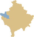
Kuqishta ( Albanian also Kuqishtë or Kuçishta / Kuçishtë , Serbian Кућиште Kućište ) is a small village in western Kosovo . It is located at the upper end of the Rugova Gorge in the Prokletije Mountains ( Albanian Alpet Shqiptare ) at 1208 m. i. J. About six kilometers from the core of the actual village there is another part of the village consisting of a hotel complex and a restaurant.
A little to the west is the border with Montenegro . The border crossing to Montenegro has been closed to traffic since the Kosovo war . Kuqishta is on the M-9 road that leads to the Čakor Pass .
The Pećka Bistrica ( Albanian Lumbardh i Pejës ) flows through the village. The summit of Leqinat (or Liqenat ) with an altitude of 1799 m. i. J. is in the south of the village. A small mountain lake on the mountain is called Leqinat Lake .
According to the 2011 census , the village had nine inhabitants, all of whom (100%) identified themselves as Albanians .
Web links
Individual evidence
- ↑ Endrit Shima et al .: Peaks of the Balkans. Cross border hiking Albania-Kosovo-Montenegro . 1: 60,000. Huber Kartographie, Munich, ISBN 978-3-943752-16-8 .
- ↑ Popullsia e komunës së Pejës sipas vendbanimit, gjinisë dhe etnicitetit 2011. In: rks-gov.net. Statistics Agency of Kosovo, accessed on June 24, 2017 (Albanian).


