Siaya
| Siaya | ||
|---|---|---|
|
|
||
| Coordinates | 0 ° 4 ′ N , 34 ° 17 ′ E | |
| Basic data | ||
| Country | Kenya | |
| ISO 3166-2 | KE | |
| height | 1224 m | |
| Residents | 22,586 (2009) | |
|
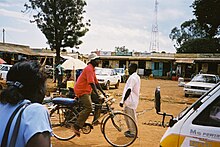
A street in town
|
||
Siaya is a city in Siaya County in Kenya . With 22,586 inhabitants (as of 2009) it is the administrative seat of the county. The provincial capital Kisumu is located 74 kilometers southeast of the city.
population
Siaya is divided into five districts: Mjini, Siaya Central, Siaya East, Siaya North and Siaya West. All neighborhoods are part of the East Alego constituency.
The population consists mainly of Luo , an ethnic group.
climate
temperature
Siaya is located in the subtropical climatic zone . In the months of June to September temperatures can drop below 20 ° C. The lowest temperatures ever recorded were 12 ° C in August and September. In the months of October to May, temperatures rise to over 35 ° C. Between December and April temperatures can be just under 40 ° C.
Precipitation
The rainy season is between March and May with a maximum monthly rainfall of around 200 mm. A smaller rainy season takes place in November and December with an average of 100 mm and a maximum of 140 mm. This rainy season is followed by the driest month in January with a mean precipitation of 48 mm and a maximum of 79 mm.
| Climate diagram | ||||||||||||||||||||||||||||||||||||||||||||||||
|---|---|---|---|---|---|---|---|---|---|---|---|---|---|---|---|---|---|---|---|---|---|---|---|---|---|---|---|---|---|---|---|---|---|---|---|---|---|---|---|---|---|---|---|---|---|---|---|---|
| ||||||||||||||||||||||||||||||||||||||||||||||||
|
Climate diagram Siaya
|
|||||||||||||||||||||||||||||||||||||||||||||||||||||||||||||||||||||||||||
traffic
Four kilometers north of the city there is a mud runway on which small planes can land. Coming from Kisumu , the city is on the highway connected C30, which is paved on these 50 kilometers.
economy
Siaya district is one of the poorest in Kenya due to low agricultural productivity and high unemployment rates.
health
Health care is also poor. The most common diseases are: malaria , dermatoses (such as AIDS or mycoses ), respiratory infections (such as tuberculosis ) and malnutrition .
- The infant mortality rate is about 50 to 200 per 1,000 births
- Malnutrition: 2.5–5% of children under 36 months
- Malaria: 20% of children under 48 months
politics
- Party in power: Orange Democratic Movement (ODM)
- Representative in the National Parliament (MP) for the five constituencies of Alego: Edwin Ochieng Yinda - Party: ODM (since 2008)
administration
Mayor: Coun Oboo Otare - Party: ODM (since 2008)
Individual evidence
- ↑ Super User: The National Treasury. Retrieved September 9, 2017 (UK English).
- ↑ Wikiwix's cache. (No longer available online.) Archived from the original on February 23, 2011 ; accessed on September 9, 2017 .
- ↑ Jane M. Kelly, Benta Osamba, Renu M. Garg, Mary J. Hamel, Jennifer J. Lewis: Community Health Worker Performance in the Management of Multiple Childhood Illnesses: Siaya District, Kenya, 1997-2001 . In: American Journal of Public Health . tape 91 , no. 10 , October 1, 2001, ISSN 0090-0036 , p. 1617–1624 , doi : 10.2105 / AJPH.91.10.1617 ( aphapublications.org [accessed September 9, 2017]).


