Sierra Madre Mountains
| Sierra Madre Mountains | ||
|---|---|---|
|
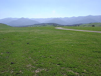
The Sierra Madre Mountains from Cottonwood Canyon Road in the Cuyama Valley |
||
| Highest peak | Peak Mountain ( 1783 m ) | |
| location | California (USA) | |
| part of | Transverse ranges | |
|
|
||
| Coordinates | 34 ° 54 ′ N , 119 ° 52 ′ W | |
The Sierra Madre Mountains are a mountain range in northern Santa Barbara County in the US state of California . They are part of the Los Angeles Ranges , which are themselves part of the mountain ranges of the North American Pacific coast . The chain strikes northwest to southeast and is approximately 40 kilometers long. Snow falls on the highest peaks during the winter months. Outstanding peaks are MacPherson Peak (1752 meters) and its highest peak, Peak Mountain (1783 meters). In the southeast, the chain connects with the San Rafael Mountains in a tangle of unnamed mountain ranges, the highest point of which is Big Pine Mountain with an altitude of 2080 meters, the highest point in Santa Barbara County.
The Sierra Madre Mountains lie almost entirely within the Los Padres National Forest and form the northern boundary of the San Rafael Wilderness . The southeasternmost point of the chain is about 40 kilometers north of Santa Barbara and the northwestern end point is about 90 kilometers north-northwest of the city.
The predominant vegetation in this mountain region is chaparral ; Oak forests exist in some areas and smaller conifer forests grow on some of the higher mountain slopes. The mountains are one of the most important habitats for the endangered California condor . The Sierra Madre Mountains rise directly south of the Cuyama Valley , which forms the northern edge of Santa Barbara County.
Geologically, the mountains consist almost entirely of sedimentary rocks from the Tertiary . For the most part, it is sandstone formed in the Eocene , an area in the east of the mountain range consists of sediments formed in the early and middle Miocene . The mountain range is bounded to the south by the Nacimiento Fault and to the north by the South Cuyama Fault and the Ozena Fault .
The mountain range is almost completely uninhabited, with the exception of the lower foothills in the north, which is developed for the production of oil and natural gas in the South Cuyama oil field . A difficult single-track slope follows the main ridge. It is often impassable after storms and can only be accessed by four-wheel drive cars and off-road motorcycles.


