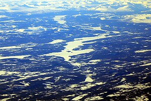
Skalka (lake)
|
Skalka Skalkkå |
||
|---|---|---|

|
||
| Aerial photo from 2019 | ||
| Geographical location | Norrbotten County , Sweden | |
| Tributaries | Tarraätno | |
| Drain | Tarraätno ( Lilla Luleälven ) | |
| Data | ||
| Coordinates | 66 ° 50 '39 " N , 18 ° 49' 57" E | |
|
|
||
| Altitude above sea level | 296 m above sea level | |
| surface | 49.1 km² | |
| Catchment area | Lule älv | |
The Skalka is a lake in the municipality of Jokkmokk in the Swedish province of Norrbotten County , which is part of the main catchment area of the Lule älv . The lake is 31 meters deep and has a total area of 49.1 square kilometers. It is 296 meters above sea level . The lake is drained via the Tarraätno, the longest source river of the Lilla Luleälven .
The Granuddens skvaltkvarn watermill is located in Kvarntjärn, north of Skalka.
The lake is accessed by the Länsväg BD 805, without reaching larger settlements. The Länsväg BD 807 also ends at the lake in the Björkholmen settlement. This hamlet is also so small that the SCB does not publish any population figures. Jokkmokk is about forty kilometers to the southeast.
Lower basin
The Skalka is part of the lower basin (741611-164246), which the Swedish administrative authority SMHI calls the “Skalka outlet”. The average altitude is 339 meters above sea level with an area of 162.36 square kilometers. If the 261 river basins that are located upstream are included, the total area is 4,828.22 square kilometers. The river Lilla Luleälven (Tarranätno) responsible for drainage is categorized as “tributary system 2”. This means that the water flows through two streams before reaching the sea after a distance of 228 kilometers. The catchment area consists of 66% forest and covers 49.68 square kilometers of water. This results in a water content of 30.6%.
Web links
Individual evidence
- ↑ Swedish Water Archives - Water Surfaces (SVAR 2012). (ZIP; 31.2 MB) In: Esri Shape. SMHI, October 7, 2012, accessed March 15, 2019 (Swedish).
- ↑ Sjölyftet. (XLS, 14.2 MB) SMHI, December 10, 2012, accessed March 15, 2019 (Swedish).
- ^ Swedish Water Archives - Underwater Basin (SVAR 2012). In: Esri Shape. SMHI, October 7, 2012, accessed March 15, 2019 (Swedish).
- ^ Swedish Water Archives - Lower Basin. (ZIP; 32.4 MB) In: Esri Shape. SMHI, October 7, 2012, accessed March 15, 2019 (Swedish).
