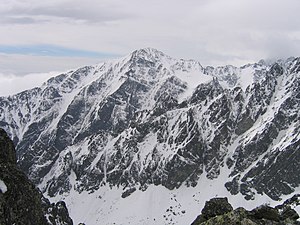
Slavkovský štít
| Slavkovský štít | ||
|---|---|---|
|
Slavskovský štít as seen from Lomnické sedlo (Lomnica Saddle) |
||
| height | 2452 m nm | |
| location | Prešovský kraj , Slovakia | |
| Mountains | High Tatras , Carpathian Mountains | |
| Coordinates | 49 ° 9 '58 " N , 20 ° 11' 5" E | |
|
|
||
| rock | Granodiorite | |
| First ascent | 1664 | |
The Slavkovský štít (German Schlagendorfer Spitze , Hungarian Nagyszalóki-csúcs ) is a 2452 m nm high mountain in the High Tatras in Slovakia .
The Slavkovský štít is located above the village of Starý Smokovec (German: Altschmecks ). It is named after the municipality Veľký Slavkov (Eng. Großschlagendorf ), on whose cadastral area the mountain once lay. To the north of the mountain lies the Veáká Studená dolina ( Great Kohlbachtal ).
The first known ascent took place in 1664 by a group around Georg Buchholtz. Today the mountain is popular with tourists because as one of the highest Tatra mountains it can be reached without a mountain guide or climbing.
The mountain can be reached from Altschmecks via a blue marked path. It takes about 5:15 h there and 3:50 h back, for a total of 9 hours. It can also be reached from Hrebienok, Horský hotel Hrebienok or Bilíková chata via a red path, which, however, joins the blue path before the summit. If there is snow cover, the path from Slavkovská výhliadka ( 1531 m nm ) is closed.

