Sleepy Eye
| Sleepy Eye | |
|---|---|
|
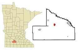
Location of Sleepy Eye in Brown County
|
|
| Basic data | |
| Foundation : | 1872 |
| State : | United States |
| State : | Minnesota |
| County : | Brown County |
| Coordinates : | 44 ° 18 ′ N , 94 ° 43 ′ W |
| Time zone : | Central ( UTC − 6 / −5 ) |
| Residents : | 3,515 (as of: 2000) |
| Population density : | 817.4 inhabitants per km 2 |
| Area : | 5.1 km 2 (approx. 2 mi 2 ) of which 4.3 km 2 (approx. 2 mi 2 ) is land |
| Height : | 312 m |
| Postal code : | 56085 |
| Area code : | +1 507 |
| FIPS : | 27-60844 |
| GNIS ID : | 0652150 |
| Website : | www.sleepyeye-mn.com |
| Mayor : | Jim Broich |
Sleepy Eye is a village of 3515 inhabitants in Brown County in the US state of Minnesota .
geography
Sleepy Eye is located south of geographic center of Minnesota on the shores of Sleepy Eye Lake . The village is approximately 138 kilometers southwest of Minneapolis and 179 kilometers northeast of Sioux Falls . The urban area has an area of 5.1 km², of which 0.7 km² is water.
history
Sleepy Eye was founded in 1872 on a railway line . The village got its name from the lake that occupies the north and west of the village. This in turn got its name after the Indian chief "Sleepy Eyes" (Ish-Tak-Ha-Ba), who settled here with his tribe at the end of the 1850s. From around 1860 the first whites settled in today's urban area. From 1883 to 1921, a flour mill drew many people to Sleepy Eye. Sleepy Eye also became known through the television series " Our Little Farm " with Michael Landon .
Worth seeing
- Sleepy Eye Lake - A lake to the north of the village.
- Obelisk Monument - Under which the bones of Chief Sleepy Eye (ISH-TAK-HA-BA) are buried.
traffic
Sleepy Eye is on US-14 . The village also has its own airport, the Sleepy Eye Municipal Airport .
Churches
- New Hope Community Church
- Calvary Baptist Church
- St. John's Evangelical Lutheran Church
- Apostolic Assembly Church
- St. Mary's Catholic Church
- Faith United Methodist Church
- Grace Evangelical Lutheran Church
- Trinity Lutheran Church
