Snipe incident
Coordinates: 54 ° 57 ′ 15 ″ S , 67 ° 8 ′ 53 ″ W.
| Beagle conflict | |
|---|---|
| Main Products: | Beagle conflict |
| 1881–1970: | Beagle cartography |
| 1958: | Snipe incident |
| 1971–1977: | Arbitration court in the Beagle conflict |
| 1977–1978: | Direct negotiations |
| 1978: | Operation Soberanía |
| 1979-1984: | Papal mediation |
| 1984: | Friendship treaty 1984 |
The conflict over the rocky island of Snipe between Chile and Argentina in 1958 is known as the Snipe incident .
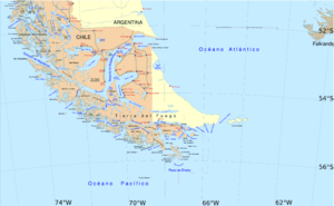
Snipe Island is located in the middle of the Beagle Channel near the nearest coasts of Picton, Navarino and Isla Grande de Tierra del Fuego .
The dispute

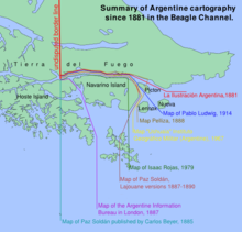
Chile and Argentina fought over sovereign rights over the zone south of the Beagle Channel (see Beagle cartography from 1881 ) and the Snipe Rock was claimed by both countries.
In 1881 Chile and Argentina signed a definitive border treaty. Argentina recognized the islands of Picton, Nueva and Lennox as well as the islands at Cape Horn as Chilean territory. Until around 1888, only maps with the islands mentioned as Chilean territory appeared in Argentina (with the exception of the maps that were marked as "eccentric" or "non-contractual" by the international arbitration tribunal in the Beagle conflict ). From 1889 maps began to be published in Argentina that showed a different border. Even so, Argentina has not had a clear new interpretation of the 1881 Border Treaty on the Beagle Channel since then. The picture on the right shows nine different Argentine interpretations of the border treaty from 1881 to 1982.
Chile always represented a single interpretation, which has been recognized by Argentina again since 1984 (as from 1881 to 1888). The Chilean interpretation is the red line on the map shown on the right, marked “La Ilustración Argentina, 1881”.
Accordingly, there was also no consensus on the place names : Chile called the waters around the rock "Beagle Channel", Argentina called them "Moat Channel" on the grounds that the Beagle Channel turns south between the islands of Navarino and Picton, so that all of the eastern islands were no longer "south of the Beagle Channel" and the border treaty of 1881 had been awarded to Argentina.
The dispute caused several incidents, including the "Ballenita" case in July 1967, the "Cruz del Sur" case in August 1967, the "Quidora" case in November 1967 and the "USS South Wind" case in February 1968. The most serious of these was the 1958 Snipe incident.
The incident
On January 12, 1958, the crew of the Chilean troop transport "Milcavi" erected a lighthouse on the rock, on May 1, 1958, the lighthouse was installed, the lighthouse was inaugurated and the corresponding international notification was issued.
In 1977, during the "Jornadas del Canal Beagle y Atlántico sur" , a series of conferences co-organized by Isaac Rojas to get the Argentine side to reject the internationally binding arbitration award, Isaac Rojas told the assembly about his memories of the days of the incident:
"Cuando fui informado del ilegítimo acto posesorio llevado a cabo por Chile, […] resolví de inmediato, como Comandante de Operaciones Navales, aconsejar una contramedida enérgica. … Yo, en persona, llevé a Ushuaia una baliza luminosa, la que en la segunda quincena de abril fue instalada en el islote Snipe en lugar de la señal chilena violadora del statu quo. "
“When I was informed of the execution of the illegitimate Chilean act, […] I immediately decided, as the commander of the sea operations, to recommend energetic countermeasures to the government. ... I personally brought a beacon to Ushuaia that was installed on Snipe in the second half of April, instead of the Chilean lighthouse that violated the "status quo". "
Before setting up their lighthouse, the crew of the Argentine Guaraní dismantled the Chilean one and threw it into the sea.
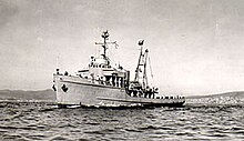
On May 11, 1958, the crew of the Chilean patrol boat Lientur dismantled the Argentine lighthouse again, loaded the parts and drove back to Puerto Williams . On May 15, the Lientur team salvaged the Chilean lighthouse from the water and also brought it to Puerto Williams.
On June 8, 1958, the Lientur team installed a lighthouse on the rock again.
On June 9, the Argentine destroyer "ARA San Juan" shelled the rock, destroyed the second Chilean lighthouse and then landed a division of marine infantry with the intention of staying there until Chile recognizes the Argentine rights to the island.
Despite the military deployment on both sides, the situation eased after direct political negotiations between the governments and was defused on August 17th. It was agreed not to build a lighthouse on the rock and the Argentine marines left the rock again.
consequences
Open war could be avoided in 1958, but the conflict lingered and 20 years later escalated to the brink of war. In 1978, after an international court awarded the disputed islands to Chile, Argentina launched Operation Soberanía to military occupy the islands south of the Beagle Channel.
Economically
From now on, as before the incident, neither Chile nor Argentina were able to colonize or use the islands, because as a result of the incident Argentina was able to establish these islands as "disputed territory".
Diplomatic
In December 1967, ten years later, as a result of the accumulation of incidents, the Chilean government, under Eduardo Frei Montalva, brought the case before the (intended) British arbitrator , first unilaterally and later jointly with Argentina.
Military
In order to counteract the materially better resourced Argentine Navy, the Chilean government passed in October 1958, just a few days before the constitutional resignation of the Ibañez government , the later very controversial Law 13.196, "Ley Reservada del Cobre", in which part of the profits from the Copper mining is planned for arms purchases without parliamentary supervision.
In order to avoid another fait accompli in advance, the Chilean military occupied the islands in 1978 before, during and after "Operation Soberanía".
today
The Snipe Rock is now an internationally recognized Chilean territory. There is also a lighthouse on the rock again.
Individual evidence
-
↑ See §148 in Report and Decision of the Court of Arbitration ( Memento of April 10, 2008 in the Internet Archive ) (PDF; 4.9 MB):
- There can be no doubt that in the immediate post-Treaty period, that is to say from 1881 to at least 1887/88, Argentine cartography in general showed the PNL group as Chilean;
- ↑ The name refers to the Argentine magazine La Ilustración Argentina , which published the map with the new border a few days after signing the contract.
- ↑ David Robert Struthers, The Beagle Channel Dispute between Argentina and Chile: An Historical Analisys ( Memento April 18, 2012 in the Internet Archive ), Thesis, 1985, page 71
- ↑ The ship is now a floating yacht club in Puerto Williams
-
↑ Rojas was chief of the Argentine navy, vice president of the country and led an active political life in his country.
See Francisco Rojas: La Argentina en el Beagle y Atlantico sur, 1 ° Parte , Chapter 4: “Conclusiones de 4 Jornadas”. - ↑ El Mercurio de Valparaiso , August 17, 2008 (accessed August 6, 2009): “que habían sido lanzadas al agua por el personal del patrullero argentino 'Guaraní'”.
- ↑ See Historia General de las Relaciones Exteriores de la República Argentina Algunas cuestiones con los países vecinos : "mantener la ocupación hasta lograr el reconocimiento por parte del gobierno chileno del carácter litigioso del islote"
- ↑ See ¿Cuál es el origen de la Ley Reservada del Cobre? ( Memento from September 16, 2008 in the Internet Archive ): "Por este hecho, se conoció también a esta norma como" Ley de las Fragatas "."
See also
- Beagle conflict
- Beagle cartography from 1881
- Arbitration court in the Beagle conflict
- Direct negotiations between Chile and Argentina 1977-78
- Operation Soberanía
- Papal mediation in the Beagle conflict
- Friendship and peace treaty of 1984 between Chile and Argentina
Bibliography
- Hugo Alsina Calderón El incidente del islote Snipe (PDF; 24 kB) in the Revista Marina de Chile, in Spanish
- El Mercurio de Valparaíso , August 17, 2008, viewed September 24, 2008, in Spanish
- Isaac Francisco Rojas (Coordinator), "La Argentina en el Beagle y Atlantico sur, (1 ° Parte)", Editorial Diagraf, in Spanish
- Michael Radseck, Raw Materials and Armaments. Background and effects of resource-financed weapons purchases in South AmericaLatin America (PDF; 405 kB), Analyzes 16, 1/2007, pp. 203–241. Hamburg: ILAS, as seen on September 23, 2008.
- Historia General de las Relaciones Exteriores de la República Argentina Algunas cuestiones con los países vecinos , as seen on September 23, 2008, in Spanish


