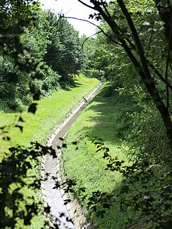
Sodinger Bach
| Sodinger Bach | ||
|
Sodinger Bach at the Börnig pumping station |
||
| Data | ||
| Water code | DE : 27723496 | |
| location | North Rhine-Westphalia , Germany | |
| River system | Rhine | |
| Drain over | Landwehrbach (Emscher) → Emscher → Rhine → North Sea | |
| source | As the outflow of the Langelohbach in Herne-Sodingen 51 ° 32 ′ 38 ″ N , 7 ° 15 ′ 2 ″ E |
|
| muzzle | In den Landwehrbach , Herne-Horsthausen Coordinates: 51 ° 33 '23 " N , 7 ° 14' 57" E 51 ° 33 '23 " N , 7 ° 14' 57" E
|
|
| length | 1.6 km | |
| Big cities | Herne | |
The Sodinger Bach is a left tributary of the Landwehrbach in Herne- Sodingen. It has an above-ground flow length of around 1.6 km.
The stream is channeled and piped. It serves as a receiving water for the wastewater and pure water flows in the eastern part of the city of Herne. As part of the project for the conversion of the Emscher system, it is planned to convert the Sodinger Bach into an open, clean water course.
The brook runs underground in the densely populated center of Sodingen and emerges north of the site of the former Mont Cenis colliery on Kantstrasse. The stream flows to the north, west of the Vossnacken nature reserve. As a result of the Ruhr mining , part of the catchment area of the Sodinger Bach is located in a polder area , so that drainage takes place via a pumping station. The confluence of the Sodinger Bach in the Landwehrbach lies immediately north of the Cologne-Mindener Railway and Josefinenstraße.
The upper reaches of the Sodinger Bach, south of the center of Sodingen, is called the Langelohbach . The Ruhmbach flowing from the Gysenberg flows into the underground part of the stream from the left.
Planned renaturation
As part of the renovation of the Emscher system , the Emschergenossenschaft plans to build an underground sewer parallel to the Sodinger Bach in the next few years and then to renaturate the brook together with the Landwehrbach . In this context, the upper course of the Ostbach is also to be transferred above ground from the left into the Sodinger Bach.
Individual evidence
- ↑ Water directory of the State Office for Nature, Environment and Consumer Protection NRW 2006 ( Memento from February 15, 2010 in the Internet Archive ) (PDF; 1.03 MB)
- ↑ Landwehrbach, 2nd EA, construction of the sewer and rainwater treatment from km 0.00 to km 2.64 in Herne as well as Sodinger Bach and Fischergraben. , Call for tenders from the Emschergenossenschaft, accessed on January 9, 2012
- ^ Ostbach - rehabilitation of the sewer and creation of a replacement drainage , tender of the Emschergenossenschaft, accessed on January 9, 2012
