
Solar eclipse of October 2, 2024
| Solar eclipse of October 2, 2024 | |
|---|---|

|
|
| classification | |
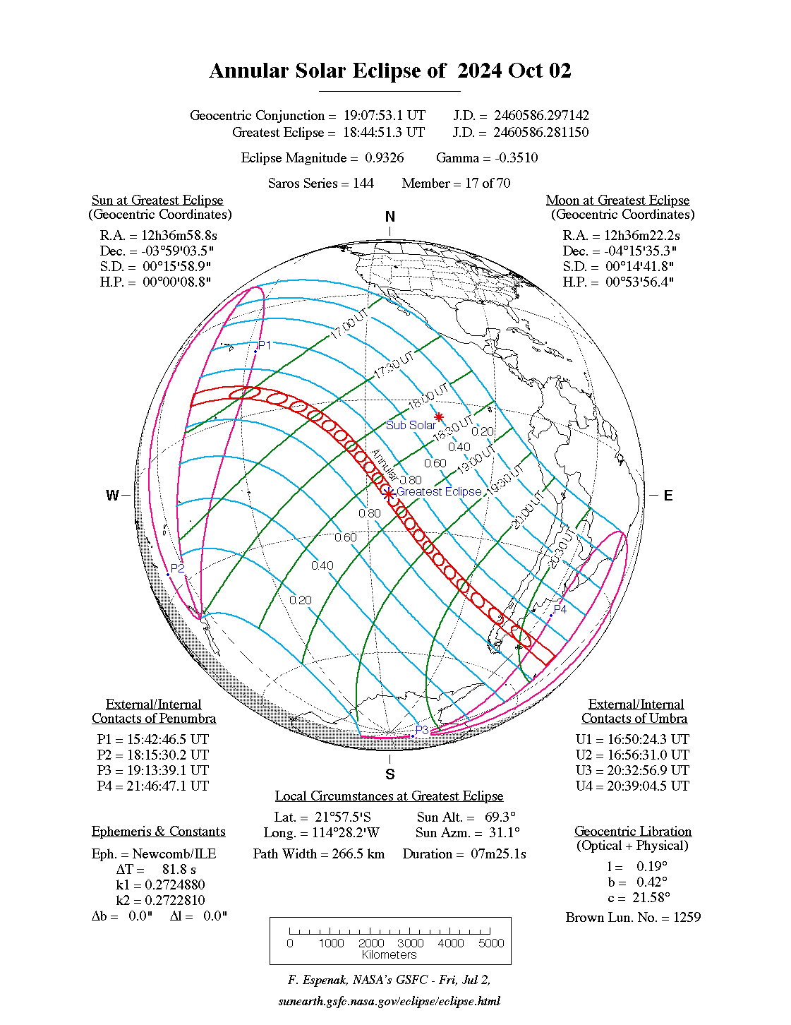
| Type | Ring-shaped |
| area |
Pacific , southern South America Annular: southern Chile , southern Argentina |
| Saros cycle | 144 (17 of 70) |
| Gamma value | -03510 |
| Greatest eclipse | |
| Duration | 7 minutes 25 seconds |
| place | South pacific |
| location | 21 ° 57 ′ S , 114 ° 28 ′ W |
| time | October 2, 2024 6:44:51 PM UT |
| size | 0.9326 |
The ring-shaped solar eclipse of October 2, 2024 mainly takes place over the South Pacific, only towards the end does the eclipse sweep the South American continent in Patagonia from west to east. The maximum of the eclipse occurs over the Pacific northwest of Easter Island , the duration of the ring-shaped phase is 7 minutes and 25 seconds.
The eclipse belongs to the Saros cycle with the number 144, which exclusively comprises ring-shaped and purely partial eclipses. The duration of the ring-shaped phase will increase to almost 10 minutes in the following eclipses in this cycle over the next 150 years.
course
The annular phase of the eclipse begins in the Pacific south of Hawaii . In Honolulu, if the weather permits, a sunrise can be observed at 16:45 UT with an approximately half-covered sun disk. From there the path runs with ring-shaped visibility in a south-easterly direction and about two hours later reaches the maximum over the South Pacific. Only a little later the shadow path sweeps over Easter Island , where in Orongo the moon is centrally located in front of the sun for 6 minutes and 20 seconds.
About 1.5 more hours later at about 20:18 UT, the shadow path reaches mainland South America on the Taitao Peninsula. The Laguna San Rafael National Park located on this peninsula is in the zone of circular visibility. On the central line, the ring-shaped phase there lasts a little more than 60 minutes and 20 seconds. The shadow path then crosses the Argentine province of Santa Cruz and reaches the Atlantic in Puerto Deseado . There the ring-shaped phase can be seen for 3 minutes and 48 seconds. In the late afternoon at 17:29 local time (20:29 UT) the sun is still about 20 degrees above the horizon.
Less than an hour later, the Shadow Trail passes north of the Falkland Islands . At Stanley , the sun is just over 80% obscured during sunset. The eclipse ends at approximately 21:46 UT about 625 kilometers north of South Georgia in the Atlantic.
Individual evidence
- ↑ Fred Espenak: NASA - Annular Solar Eclipse of 2024 Oct 02. Global Map.
- ↑ Fred Espenak: NASA - Catalog of Solar Eclipses of Saros 144.
- ↑ Fred Espenak: NASA - Annular Solar Eclipse of 2024 Oct 02. Google Maps and Solar Eclipse Paths.
Web links
- Fred Espenak: NASA - Solar Eclipses: 2021-2030.
|
Previous solar eclipses:
|
Later solar eclipses:
|
|||||||||
|
April 30, 2022 (partial) |
October 25, 2022 (partial) |
April 20, 2023 (hybrid) |
October 14, 2023 (ring-shaped) |
April 8, 2024 (total) |
October 2, 2024 (ring-shaped) |
March 29, 2025 (partial) |
September 21, 2025 (partial) |
February 17, 2026 (ring-shaped) |
August 12, 2026 (total) |
February 6, 2027 (ring-shaped) |
|
|
|
|
|
|
|
|
|
|
|
|
| Lists: 20th century • 21st century • All lists | ||||||||||