
Santa Cruz Province (Argentina)
| Basic data | |
|---|---|
 ( Details ) |
 ( Details ) |
| Capital: | Río Gallegos |
| Surface:
- Total |
Rank 2 of 24 243,943 km² |
|
Population :
- Total 2010 |
Rank 23 of 24
273,964 inhabitants |
 .svg) |
|
| ISO 3166-2 code: | AR-Z |
| politics | |
| Region : | Patagonica region |
| Structure: | 7 departments |
| Gobernador: | Alicia Kirchner de Mercado |
| Website of the province of Santa Cruz | |
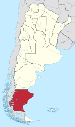
Santa Cruz ( Spanish for "Holy Cross") is one of the four provinces in the Argentine part of Patagonia . It takes its name from the Santa Cruz River, which forms the drain of Lake Argentino and flows into the Atlantic . In the north runs the dead straight border with the province of Chubut . In the east Santa Cruz borders on the Atlantic Ocean , in the west and south on Chile . After Buenos Aires , Santa Cruz is the country's second largest province.
Geography and climate

The landscape is typical of Patagonia . The Andes limit the province to the west. A chain of glacier fields and lakes follows to the east in the immediate Voranden region, the largest of which is Lake Argentino . The largest part, however, is taken up by the dry plain land of the Patagonian Mesetas, which extends to the Atlantic .
The climate is cool and temperate, with moderately warm summers (11 ° C in the south to 18 ° C in the northeast) and cold winters with little snowfall (0 ° C in the southwest, 6 ° C in the northeast). The amount of precipitation is between 150 mm in the east and 450 mm in the west, whereby the winter, especially in the Andes region, is slightly more humid than the summer.
population
Santa Cruz is the most sparsely populated province in Argentina. The population is concentrated in a few urban settlements, large parts are almost uninhabited. In the west there are isolated reserves that are inhabited by indigenous people of the Tehuelche peoples. However, their number is now low.
Important cities
There are only a few cities or places worth mentioning in Santa Cruz:
- Río Gallegos (95.796 Ew.), The provincial capital, airport ( IATA code RGL)
- Caleta Olivia (51.733 Ew.), Center of the oil production
- El Calafate (16.655 Ew.), Airport (IATA code FTE), especially tourism, starting point for tours to the Los Glaciares National Park
- Pico Truncado (20.889 Ew.), Center of natural gas production
- Las Heras (17.821 Ew.)
- Puerto Deseado (14,183 Ew.)
- Puerto San Julián (7,894 Ew.)
- Río Turbio (8,814 Ew.), Center of coal mining in the southern Andes, with winter sports center
- Comandante Luis Piedra Buena (6,405 Ew.)
- Perito Moreno (4,617 Ew.), Local center of cattle breeding
The population figures come from the 2010 Census
Administrative division
The province of Santa Cruz is divided into seven departments :
|

Economy and Infrastructure
The province lives mainly from agriculture (especially cattle breeding) and from the oil and gas production in the north of the province, but also from fishing , mining and tourism . In the southwest, near the city of Río Turbio , are the most important coal deposits in Argentina. However, dismantling has lost importance in recent decades due to a lack of investment by the operators.
A road connection (via ferry) from the province of Santa Cruz to the southernmost Argentine province of Tierra del Fuego only exists via Punta Delgada in Chile .
Web links
Buenos Aires | Catamarca | Chaco | Chubut | Cordoba | Corrientes | Entre Ríos | Formosa | Jujuy | La Pampa | La Rioja | Mendoza | Misiones | Neuquén | Río Negro | Salta | San Juan | San Luis | Santa Cruz | Santa Fe | Santiago del Estero | Tierra del Fuego | Tucuman
Coordinates: 48 ° 49 ′ S , 69 ° 49 ′ W