
Solar eclipse of April 8, 2024
| Solar eclipse of April 8, 2024 | |
|---|---|

|
|
| classification | |
| Type | Total |
| area |
Pacific , Central America , North America Total: Central Pacific , Mexico , USA , Canada |
| Saros cycle | 139 (30 of 71) |
| Gamma value | +0.3432 |
| Greatest eclipse | |
| Duration | 4 minutes 28 seconds |
| place | northern mexico |
| location | 25 ° 17 ′ N , 104 ° 7 ′ W |
| time | April 8, 2024 6:17:13 PM UT |
| size | 1.0565 |

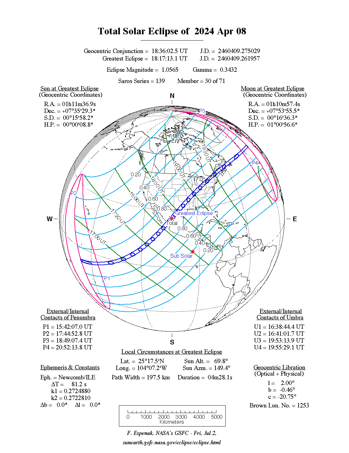
The total solar eclipse on Monday, April 8, 2024 takes place largely over the Central Pacific , Central America , North America and the northern Atlantic . The maximum of the eclipse is in the northwest of the Mexican state Durango near the town of Nazas in the mountains of the Sierra Madre Occidental . The duration of the total phase is there at 4 minutes and 28 seconds, the sun is 69.8 ° above the horizon.
The solar eclipse belongs to the Saros cycle 139 and is the successor to the solar eclipse of March 29, 2006 .
course
The umbra first reaches Earth in the western Pacific at 158 ° 17 ′ west longitude and 7 ° 48 ′ south latitude at 16h 40m UT . On his way to the northeast, he only encounters land after 74 minutes on the Revillagigedo Islands, some 400 km off the Mexican coast . The shadow path then reaches the mainland and first leads over the Mexican states of Sinaloa , Durango and Coahuila before it crosses several states in the USA , from southwest to northeast it leads over Texas , Oklahoma , Arkansas , Missouri , Illinois , Kentucky , Indiana , Ohio , Pennsylvania , New York , Vermont , New Hampshire, and Maine , as well as tiny parts of Tennessee and Michigan . In the northeastern part, the shadow path initially runs partly over Canada , the provinces of Ontario and Québec and then over New Brunswick , Prince Edward Island and the island of Newfoundland ( Newfoundland and Labrador ). To the east of Newfoundland, the umbra only crosses the open Atlantic and leaves the earth again at 20 ° 4 ′ west longitude and 47 ° 39 ′ north latitude at 19h 54m UT .
In the totality strip are the tourist centers of Mazatlán on the Mexican Pacific coast, Niagara Falls on the border between the USA and Canada and Lake Placid in the Adirondack Mountains . Many metropolitan areas are in the totality zone, others such as San Antonio , Columbus , Cincinnati and Toronto partially or just outside. The strip touches the north-western part of the Sierra de Órganos National Park in Mexico and crosses the Kouchibouguac and Terra Nova National Parks in Canada .
About 200 km west of the Texas city of Austin, at Vanderpool in Bandera County , is the intersection of the central line of the annular solar eclipse of October 14, 2023 , so that two central solar eclipses can be seen here less than 6 months apart.
In southern Illinois, Carbondale is located for the second time, in less than seven years, near the central line of a total solar eclipse. A total of 2 minutes and 38 seconds could already be observed here on August 21, 2017 .
Places in the totality zone
| country | place | Duration | Time ( UT ) | comment |
|---|---|---|---|---|
| Mexico | Isla Socorro | 3m 18s | 17h 54m | first contact with land |
| Mexico | Mazatlan | 4m 18s | 18h 10m | Transition to the mainland |
| Mexico | Durango | 3m 40s | 18h 14m | |
| Mexico | Torreón | 4m 6s | 18h 19m | |
| Mexico | Piedras Negras | 4m 24s | 18h 30m | Mexico / USA border |
| United States | Vanderpool , Texas | 4m 26s | 18h 33m | at the intersection of the central line of the annular solar eclipse of October 14, 2023 |
| United States | Austin , Texas | 1m 41s | 18h 37m | on the southern edge of the totality zone |
| United States | Dallas , Texas | 3m 51s | 18h 42m | |
| United States | Little Rock , Arkansas | 2m 17s | 18h 53m | |
| United States | Carbondale , Illinois | 4m 8s | 19h 01m | near the intersection of the central line of the total solar eclipse on August 21, 2017 |
| United States | Indianapolis , Indiana | 3m 50s | 19h 08m | |
| United States | Cleveland , Ohio | 3m 49s | 19h 16m | |
| USA / Canada | Niagara Falls , New York / Ontario | 3m 30s | 19h 20m | USA / Canada border |
| Canada | Montreal , Quebec | 1m 26s | 19h 27m | on the northern edge of the totality zone |
| Canada | Fredericton , New Brunswick | 2m 13s | 19h 35m | |
| Canada | Terra Nova National Park , Newfoundland | 2m 55s | 19h 45m | Transition to the North Atlantic |
Web links
- solar-eclipse.de: The total solar eclipse from April 8th, 2024
- NASA: Total Solar Eclipse of 2024 Apr 8
- NASA: Google Maps and Solar Eclipse Paths: 2021-2040
- NASA: Solar Eclipses of Saros 139
- NASA: Interactive Map for Total Solar Eclipse of 2024 Apr 8
- NASA: Path of Total Solar Eclipse of 2024 Apr 8
Individual evidence
- ^ A b Fred Espenak : Fifty Year Canon of Solar Eclipses: 1986-2035 . Ed .: NASA . 2nd Edition. Sky Publishing, Belmont 1994, ISBN 0-933346-45-X , pp. 122, 226 .
- ↑ a b The duration of the totality and the time of the middle of the totality were determined with the interactive map of NASA.
- ↑ Mark Littmann, Fred Espenak, Ken Willcox: Totality: Eclipses of the Sun . 3. Edition. Oxford University Press, New York 2008, ISBN 978-0-19-953209-4 , pp. 262 .
|
Previous solar eclipses:
|
Later solar eclipses:
|
|||||||||
|
4 December 2021 (total) |
April 30, 2022 (partial) |
October 25, 2022 (partial) |
April 20, 2023 (hybrid) |
October 14, 2023 (ring-shaped) |
April 8, 2024 (total) |
October 2, 2024 (ring-shaped) |
March 29, 2025 (partial) |
September 21, 2025 (partial) |
February 17, 2026 (ring-shaped) |
August 12, 2026 (total) |
|
|
|
|
|
|
|
|
|
|
|
|
| Lists: 20th century • 21st century • All lists | ||||||||||