
Solar eclipse of August 21, 2017
| Solar eclipse of August 21, 2017 | |
|---|---|
.gif) Animation of the shadow path of the solar eclipse on August 21, 2017 |
|
| classification | |
| Type | Total |
| area |
North America , Northern South America Total: North Pacific , USA , Atlantic |
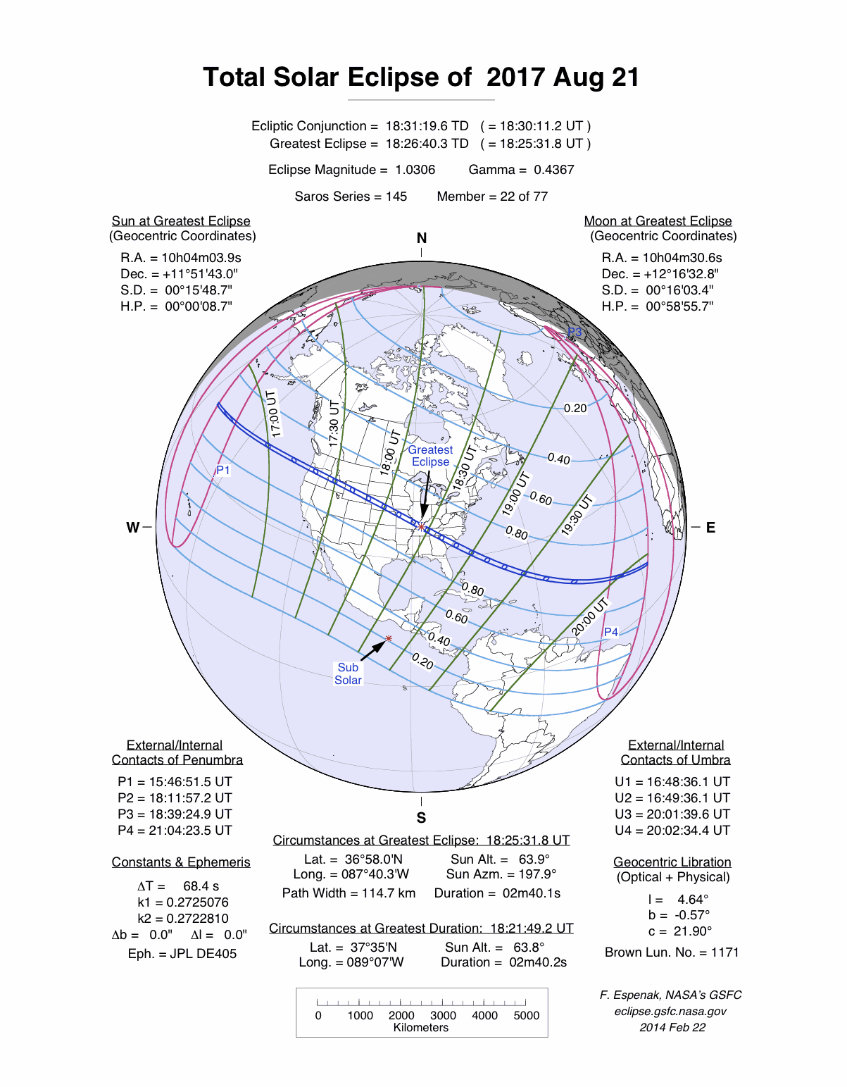
| Saros cycle | 145 (22 of 77) |
| Gamma value | 0.4367 |
| Greatest eclipse | |
| Duration | 2 minutes 40 seconds |
| place | Northwest of Nashville |
| location | 36 ° 58 ′ N , 87 ° 40 ′ W |
| time | August 21, 2017 18: 25: 31.8 UT |
| size | 1.0306 |
The total solar eclipse of August 21, 2017 was mainly observed on the North American continent . The umbra of the moon covered the United States from the west to the east coast. The last solar eclipse to be seen on the US mainland, the total solar eclipse on February 26, 1979, was more than 38 years ago at this point in time. The 2017 eclipse began in the Pacific and ended in the Atlantic ; outside of the American continent, the umbra did not hit land. On his way from the northwest to the southeast coast of the United States, he covered a total of 14 US states: Oregon , Idaho , Wyoming , Nebraska , Kansas , Missouri , Illinois , Kentucky , Tennessee , Georgia , North and South Carolina as well as tiny parts of Montana and Iowa .
The partial phase of the eclipse could be seen throughout North America and Greenland , as well as in Central America and northern South America . In the far west of Africa and Europe , under ideal conditions towards the end of the eclipse, a slight eclipse could be observed by the moon shortly before sunset.
This solar eclipse with a maximum total duration of 2 minutes and 40 seconds followed in Saros cycle 145 the eclipse of August 11, 1999 , whose totality zone crossed Central Europe. It was the last in the 20th century.
course

About 1500 kilometers south of the Aleutian Islands , the umbra of the moon in the middle of the Pacific Ocean first hit the surface of the earth at 16:50 UT ( Universal Time ). While the umbra covered the nearly 3,900 kilometers to the west coast of the United States across the Pacific in about 27 minutes, the width of the totality zone increased from initially 62 to 100 kilometers. The first American city to be hit by the umbra was Newport , Oregon . There the duration of the totality was already 1 minute and 44 seconds. A little later the umbra reached Salem , the capital of the state. From 10:17 local time , the morning sun, which was almost 40 ° above the horizon, was covered by the moon for almost two minutes. The umbra then crossed Idaho , with the cities of Stanley and Rexburg near the central line. Then the totality reached the state of Wyoming and ran through the middle of Grand Teton National Park , Yellowstone National Park was a little too far north. A little later, the umbra crossed the Wind River Range and its highest peak, Gannett Peak , which, at 4209 meters, was the highest point in this eclipse that was hit by the umbra. From Casper , the umbra followed the course of the North Platte River and reached the state of Nebraska . In the totality zone there was also Chimney Rock , a prominent landmark for settlers who had once moved west on the Oregon Trail .
In Nebraska, the shadow zone left the mountainous regions of the Rocky Mountains and crossed the Great Plains . First, from North Platte , the shadow path followed Interstate 80 for 400 kilometers to Lincoln , the capital of the state, which was on the northern edge of the totality zone. Upstream from St. Joseph , the umbra reached the Missouri and followed it almost to its confluence with the Mississippi near St. Louis . The metropolitan regions of St. Louis and Kansas City were located on the southern and northern edges of the totality zone, respectively. The east-west section of Interstate 70 connecting the two cities led across the shadow zone. On its way from Nebraska to Missouri, the shadow corridor still grazed the northeast of the state of Kansas and a tiny corner of the southwest of Iowa . The umbra then crossed the Mississippi and reached Illinois . At a distance of about 10 km, the central line ran south of Carbondale , where the moon eclipsed the sun for 2 minutes and 37 seconds. Less than seven years after this, Carbondale will experience another totality of over four minutes during the solar eclipse of April 8, 2024 . In 2024, the central line will pass Carbondale at a distance of only about 5 km to the southeast and the 210 km wide shadow path that runs from southwest to northeast crosses the 110 km wide shadow path of the 2017 eclipse.


To the south of Illinois the umbra swept west of Kentucky , where the darkness reached its maximum. A little northwest of Hopkinsville , the total eclipse of the sun on the central line stopped for 2 minutes and 40 seconds from 1:24 pm local time . The width of the umbra zone was 115 kilometers here, the sun was 64 ° above the horizon. Further to the southeast, the umbra in Tennessee reached the southern states , Nashville was in the umbra zone and experienced a totality of 1 minute and 55 seconds. Then the umbra crossed the southern part of the Appalachian Mountains , the Great Smoky Mountains National Park was in the totality zone. The point where Georgia , North, and South Carolina meet was near the center line, so the total solar eclipse could be observed in all three states, but visibility was limited to a small area with the exception of South Carolina. Columbia in South Carolina was the fifth capital in the totality zone after Salem , Lincoln , Jefferson City and Nashville and achieved the longest totality time with 2 minutes and 30 seconds.
At 14:49 local time , the umbra left the American continent in the Cape Romain National Wildlife Refuge on the southeast coast of South Carolina. On its further way across the Atlantic , the umbra no longer hit land, the Bermuda Islands are 800 kilometers too far to the north, the Bahamas about the same distance too far to the south. Near the equator, about 300 kilometers west of the African coast, the umbra detached from the earth during sunset.
Places in the totality zone
| country | place | Duration | Time ( UT ) | comment |
|---|---|---|---|---|
| United States | Newport , Oregon | 1m 44s | 17h 17m | Umbra reaches the mainland |
| United States | Salem , Oregon | 1m 54s | 17h 18m | |
| United States | Idaho Falls , Idaho | 1m 45s | 17h 34m | |
| United States | Casper , Wyoming | 2m 26s | 17h 44m | |
| United States | Lincoln , Nebraska | 1m 11s | 18h 3m | on the northern edge of the totality zone |
| United States | Kansas City , Missouri | 0m 24s | 18h 9m | on the southern edge of the totality zone |
| United States | Columbia , Missouri | 2m 36s | 18h 14m | |
| United States | Carbondale , Illinois | 1m 37s | 18h 21m | near the point of intersection of this with the central line of the total solar eclipse of April 8, 2024 |
| United States | Hopkinsville , Kentucky | 2m 40s | 18h 26m | |
| United States | Nashville , Tennessee | 1m 55s | 18h 28m | |
| United States | Cherokee , North Carolina | 1m 23s | 18h 36m | |
| United States | Columbia , South Carolina | 2m 31s | 18h 43m | |
| United States | Charleston , South Carolina | 1m 32s | 18h 47m | Transition to the North Atlantic |
Course in Europe

In Europe, the eclipse was only partially visible in north-western Europe in the evening or at sunset. Essentially, Great Britain, Norway, the Netherlands, Belgium, France, Spain and Portugal benefited from the darkness.
The partial coverage of the sun reached about 28% on the Azores island of São Miguel and about 33% on Madeira . In Las Palmas de Gran Canaria around 40% was reached at sunset. On the west coast of the Iberian Peninsula , at sunset a coverage between 13% in the north and 22% in the south was achieved. On the French Atlantic coast, the maximum degree of coverage was around 10%, on the west coast of the British Isles it was significantly lower. In Germany, only in the extreme northwest and on Borkum and only under the best weather conditions could the beginning of the eclipse be seen at sunset with a slight coverage of less than one percent at sunset.
Research projects
A project was initiated to intensify research into the physical properties of the solar corona by observing the solar eclipses of the 2020s , with the eclipse in August 2017 playing a key role. The advances in image processing and the technical improvements in detectors in recent years make it possible to use the diagnostic tools available in the near infrared and in the visible range of light. The investigation of the emission lines of these wavelength ranges has various advantages over the ultraviolet range, among other things that during the excitation process the proportion of radiation excitation is comparatively high compared to that of shock excitation.
A research group led by Hugh S. Hudson is asking for the help of amateur photographers for their “Megamovie” project in order to be able to put together a film that shows the eclipsed sun during the hour and a half that the umbra will take to cross the American continent. It is hoped that it will provide new insights into the solar corona , which cannot be obtained from the eclipse recordings made from one location - these high-quality recordings are limited to the duration of totality in one place. Compared to the images of the coronographs currently in space , the researchers hope for faster image sequences and images with higher resolution as well as information about areas of the corona that these coronographs cannot cover.
Merging the recordings of different origins and quality requires special calibration procedures , and incomplete or incorrect position information and image information can also be expected. The software used for calibration also makes it possible to repeat Eddington's experiment carried out during the solar eclipse of 1919 to test the general theory of relativity using today's digital cameras . Although current radio astronomical methods are far more accurate and such an experiment has little scientific value, it is still hoped that the personal examination of Einstein's theory will motivate many amateur photographers to take part in the megamovie project. The constellation for testing the deflection of starlight by the gravitational force of the sun is favorable for the 2017 eclipse, because Regulus , the main star of Leo and a star of the first magnitude , is only about one degree east of the eclipsed sun. Its apparent position would have to shift 0.74 arc seconds from its actual position during the maximum of the eclipse .
Impressions

Complete eclipse of the sun in South Carolina

Phase immediately at the end of complete eclipse


The following solar eclipses
The next four eclipses following this eclipse are all purely partial. In 2018, when there is no central eclipse, partial solar eclipses occur on February 15 , July 13 and August 11 . The latter eclipse can be seen from northern Europe. In 2019 there will be another partial eclipse on January 6th , before a total solar eclipse only follows on July 2nd, 2019 , over 22 months after the eclipse of August 2017.
The shadow axis of the moon's shadow will hit the United States two more times in the next ten years: First of all, in the ring-shaped eclipse of October 14, 2023, the moon's shadow will hit the North American continent from the west at a very similar point as in Oregon in 2017, the shadow path then runs more south to Texas than in 2017 . Less than six months after this eclipse, the umbra of the Moon again sweeps across the United States from Texas to Maine on April 8, 2024 .
The next solar eclipse visible in German-speaking countries will take place on June 10, 2021 .
literature
- Mark Littmann, Fred Espenak, Ken Willcox: Totality: Eclipses of the Sun. Third edition, Oxford University Press, New York 2008, ISBN 978-0-19-953209-4 .
- Wolfgang Held: Solar and lunar eclipses and the most important astronomical constellations up to 2017. Verlag Freies Geistesleben, Stuttgart 2005, ISBN 3-7725-2231-9 .
Web links
- The total solar eclipse of August 21, 2017. At: solar-eclipse.de.
- Total Solar Eclipse of 2017 August 21 . At: NASA.gov.
- Interactive Map for Total Solar Eclipse of 2017 Aug 21. At: NASA.gov.
- Solar Eclipses of Saros 145. At: NASA.gov.
- On August 21, 2017 - A Total Eclipse of the Sun. At: shadowandsubstance.com. Animated map showing the course of the eclipse in some cities in the USA.
Individual evidence
- ^ Littmann, Espenak, Willcox: Totality: Eclipses of the Sun. Pp. 253-258, see literature.
- ^ Littmann, Espenak, Willcox: Totality: Eclipses of the Sun. P. 262 ff., See literature.
- ↑ NASA: Interactive Map for Total Solar Eclipse of 2017 Aug 21.
- ^ Littmann, Espenak, Willcox: Totality: Eclipses of the Sun. P. 264 f., See literature.
- ^ Littmann, Espenak, Willcox: Totality: Eclipses of the Sun. P. 265 f., See literature.
- ↑ a b The duration of the totality and the time of the middle of the totality were determined with the interactive map of NASA.
- ↑ Mark Littmann, Fred Espenak, Ken Willcox: Totality: Eclipses of the Sun . 3. Edition. Oxford University Press, New York 2008, ISBN 978-0-19-953209-4 , pp. 262 .
- ↑ The cover values were taken from the interactive map of NASA Total Solar Eclipse of 2017 Aug 21 - Google Maps and Solar Eclipse Paths .
- ^ Littmann, Espenak, Willcox: Totality: Eclipses of the Sun. P. 253 ff.
- ↑ Shadia R. Habbal, John Cooper, Adrian Daw, Adalbert Ding, Miloslav Druckmuller, Ruth Esser, Judd Johnson, Huw Morgan: Exploring the Physics of the Corona with Total Solar Eclipse Observations. 2011 ( arxiv : 1108.2323v1 ).
- ^ A b Hugh S. Hudson, Scott W. McIntosh, Shadia R. Habbal, Jay M. Pasachoff, Laura Peticolas: The US Eclipse Megamovie in 2017: a white paper on a unique outreach event. 2011 ( arxiv : 1108.3486v3 ).
|
Previous solar eclipses:
|
Later solar eclipses:
|
|||||||||
|
March 20, 2015 (total) |
September 13, 2015 (partial) |
March 9, 2016 (total) |
September 1, 2016 (circular) |
February 26, 2017 (ring-shaped) |
August 21, 2017 (total) |
February 15, 2018 (partial) |
July 13, 2018 (partial) |
August 11, 2018 (partial) |
January 6, 2019 (partial) |
July 2, 2019 (total) |
|
|
|
|
|
|
|
|
|
|
|
|
| Lists: 20th century • 21st century • All lists | ||||||||||