
Solar eclipse of February 15, 2018
| Solar eclipse of February 15, 2018 | |
|---|---|
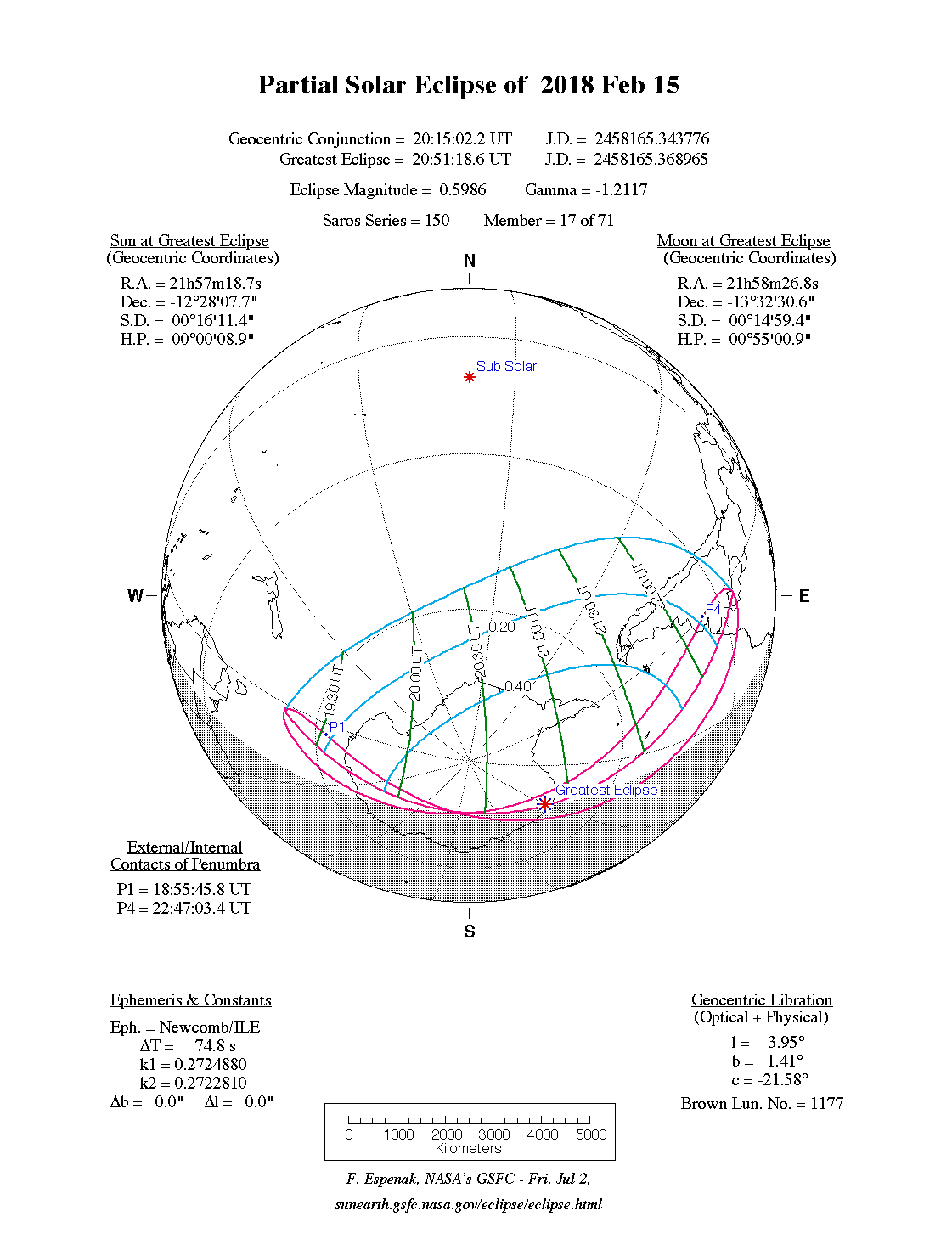
 Course of the penumbra on the earth's surface |
|
| classification | |
| Type | Partially |
| area | Antarctica , southern South America |
| Saros cycle | 150 (17 of 71) |
| Gamma value | −1.2117 |
| Greatest eclipse | |
| place | Antarctic |
| location | 71 ° 0 ′ S , 0 ° 36 ′ E |
| time | February 15, 2018 20:51:19 UT |
| size | 0.5986 |

The solar eclipse of February 15, 2018 was a purely partial eclipse, so the earth was only hit by the penumbra of the moon.
Degree of coverage

The largest eclipse took place in Antarctica at the coordinates 71 ° 0 ′ N , 0 ° 36 ′ E in Queen Maud Land . The visibility area covered two thirds of the Antarctic continent and parts of the South American countries Chile, Argentina, Uruguay, Paraguay and Brazil. However, in Uruguay, in the Argentine metropolitan area of Buenos Aires and in southern Brazil ( Rio Grande do Sul , Santa Catarina , Paraná ) the solar eclipse took place with only a low degree of coverage during sunset. The degree of coverage was also low in Santiago de Chile .
Web links
- NASA: Partial Solar Eclipse of 2018 February 15
- Solar Eclipses of Saros 150
- timeandate: world map of the degree of coverage
|
Previous solar eclipses:
|
Later solar eclipses:
|
|||||||||
|
September 13, 2015 (partial) |
March 9, 2016 (total) |
September 1, 2016 (circular) |
February 26, 2017 (ring-shaped) |
August 21, 2017 (total) |
February 15, 2018 (partial) |
July 13, 2018 (partial) |
August 11, 2018 (partial) |
January 6, 2019 (partial) |
July 2, 2019 (total) |
December 26, 2019 (circular) |
|
|
|
|
|
|
|
|
|
|
|
|
| Lists: 20th century • 21st century • All lists | ||||||||||