
Solar eclipse of July 13, 2018
| Solar eclipse of July 13, 2018 | |
|---|---|
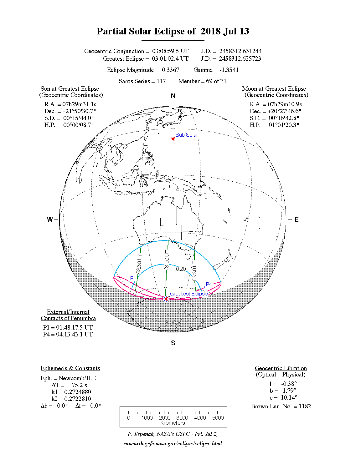
 Course of the penumbra on the earth's surface |
|
| classification | |
| Type | Partially |
| area | Sea between Antarctica and Australia |
| Saros cycle | 117 (69 of 71) |
| Gamma value | −1.3541 |
| Greatest eclipse | |
| place | East Antarctica |
| location | 67 ° 54 ′ S , 127 ° 24 ′ E |
| time | July 13, 2018 3:01:02 AM UT |
| size | 0.3367 |

The solar eclipse of July 13, 2018 is a purely partial eclipse , so the earth is only hit by the moon's penumbra. The darkness belongs to old Saros 117, which is nearing its end. Only three Saros periods later in August 2072 there will be no more solar eclipses at all. That is why there will be another modest partial solar eclipse one month later on August 11th. However, this takes place in the north polar region and belongs to the young Saros 155.

The visibility area includes the ocean surface between Australia and Antarctica ; whereby only a small tip of both continents is recorded. As with all purely partial solar eclipses, the maximum phase is reached near the pole, with the sun always on the horizon at the location of the maximum phase . The greatest eclipse will Antarctic Territory under the coordinates in the Australian 67 ° 54 ' N , 127 ° 24' O instead. The area around the Australian metropolis Melbourne and the area around Adelaide , however, experienced a very modest solar eclipse; only 2 percent of the sun's surface is covered by the moon . Parts of South Australia, Tasmania , parts of Victoria and Macquarie Island are covered by the penumbra of the moon, the rest of Australia goes empty-handed. In New Zealand, a few islands ( Auckland Islands , Campbell Island and Broughton Island ) and an uninhabited part of Southland are also covered.
Web links
- NASA: Partial Solar Eclipse of 2018 July 13
- Solar Eclipses of Saros 117
- timeandate: world map of the degree of coverage
|
Previous solar eclipses:
|
Later solar eclipses:
|
|||||||||
|
March 9, 2016 (total) |
September 1, 2016 (circular) |
February 26, 2017 (ring-shaped) |
August 21, 2017 (total) |
February 15, 2018 (partial) |
July 13, 2018 (partial) |
August 11, 2018 (partial) |
January 6, 2019 (partial) |
July 2, 2019 (total) |
December 26, 2019 (circular) |
June 21, 2020 (circular) |
|
|
|
|
|
|
|
|
|
|
|
|
| Lists: 20th century • 21st century • All lists | ||||||||||