
Solar eclipse of December 26, 2019
| Solar eclipse of December 26, 2019 | |
|---|---|

|
|
| classification | |
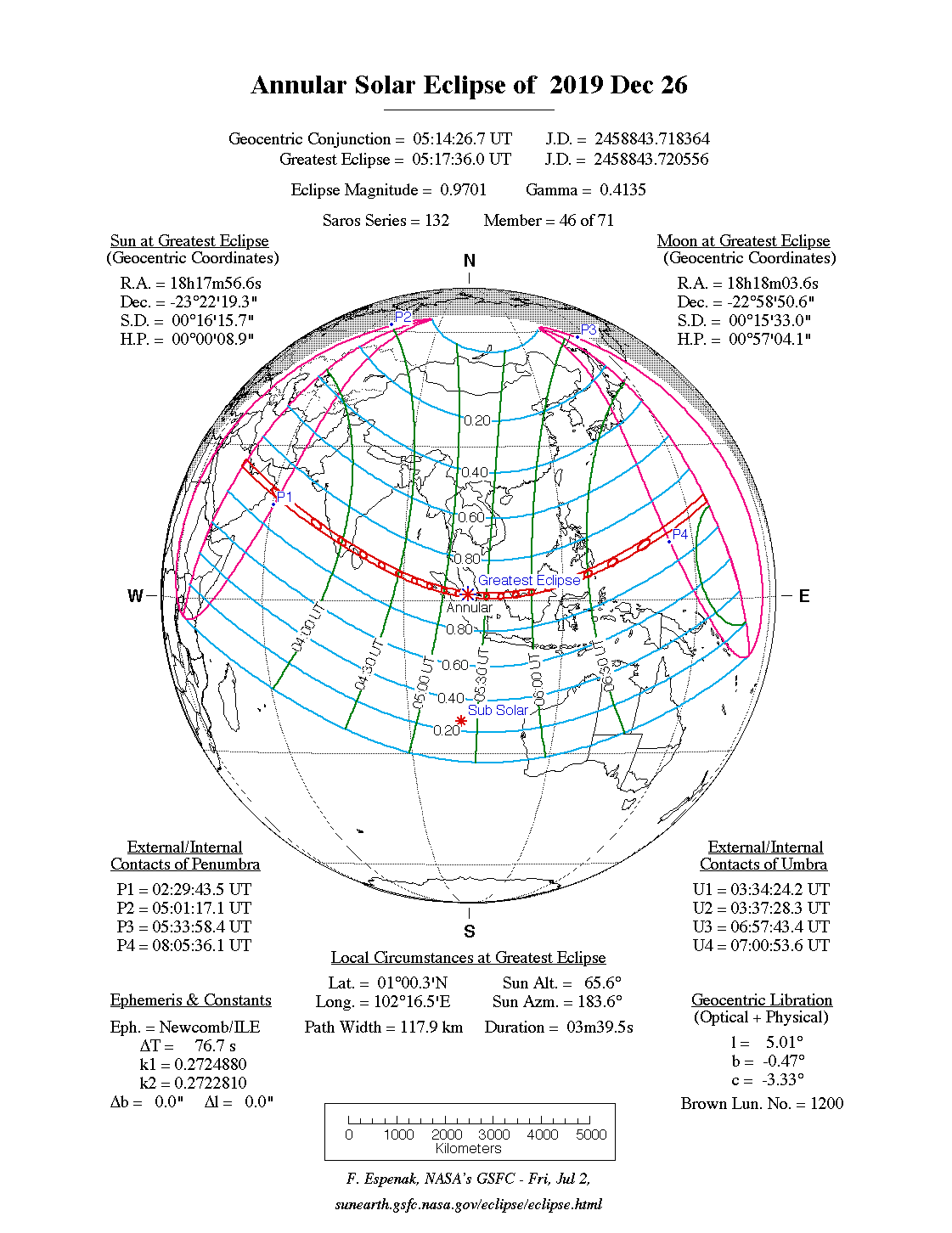
| Type | Ring-shaped |
| area |
Asia , Australia Annular: Saudi Arabia , India , Sumatra , Borneo |
| Saros cycle | 132 (46 of 71) |
| Gamma value | 0.4135 |
| Greatest eclipse | |
| Duration | 3 minutes 40 seconds |
| place | Sumatra |
| location | 1 ° 1 ′ N , 102 ° 15 ′ E |
| time | December 26, 2019 5:17:36 UT |
| size | 0.9701 |

The annular solar eclipse of December 26, 2019 took place mainly in Southeast Asia . Overall, including the areas of partial visibility, the visibility area comprised much of the most densely populated areas on earth.
In addition to large parts of Asia, the eclipse could also be observed in its partial phase in New Guinea and in northern Australia .
course
The annular phase of the eclipse was first seen in the southeast of the Arabian Peninsula . The zone of circular visibility then migrated across the Arabian Sea and reached the Indian subcontinent near Mangalore . The ring-shaped eclipse there lasted about 2 minutes and 20 seconds.
The corridor of circular visibility continued southeast across India and crossed northern Sri Lanka before continuing across the Indian Ocean . On the island of Simeuluë to the west of Sumatra , the shadow path reached the mainland again. This island was only a few kilometers away from the epicenter of the seaquake on December 26, 2004 , the island was shifted 15 meters in a south-westerly direction.
After the shadow zone had crossed the island of Sumatra, the longest duration of the annular phase of 3 minutes and 40 seconds occurred in the Strait of Malacca between the main island and the east coast of Sumatra's island Pulau Pandang . The zone with ring-shaped visibility then grazed the southern tip of the Malay Peninsula , with Singapore lying on the northern edge of this corridor and having a ring-shaped visibility of 2 minutes and 12 seconds. The corridor continued through Borneo , touched the Philippines to the far south, and then crossed the western Pacific Ocean .

In Guam the corridor crossed the mainland again, the island was on the central line of darkness, so there was another long visibility with 3 minutes and 10 seconds. The eclipse occurred there in the late afternoon at 4:56 pm local time, the sun was still a little more than 13 degrees above the horizon.
Trivia
In the ring-shaped eclipse zone, there were areas that were hardest hit by the tsunami on Boxing Day 2004 , exactly 15 years after this disaster.
Web links
- solar-eclipse.de: The annular solar eclipse of December 26th, 2019
- Astro Corner: 12/26/2019 - Annular solar eclipse
- NASA: Total Solar Eclipse of 2019 Dec 26
- NASA: Google Maps and Solar Eclipse Paths: 2001–2020
- NASA: Solar Eclipses of Saros 132
|
Previous solar eclipses:
|
Later solar eclipses:
|
|||||||||
|
February 15, 2018 (partial) |
July 13, 2018 (partial) |
August 11, 2018 (partial) |
January 6, 2019 (partial) |
July 2, 2019 (total) |
December 26, 2019 (circular) |
June 21, 2020 (circular) |
December 14, 2020 (total) |
June 10, 2021 (circular) |
4 December 2021 (total) |
April 30, 2022 (partial) |
|
|
|
|
|
|
|
|
|
|
|
|
| Lists: 20th century • 21st century • All lists | ||||||||||