
Solar eclipse of September 1, 2016
| Solar eclipse of September 1, 2016 | |
|---|---|

|
|
| classification | |
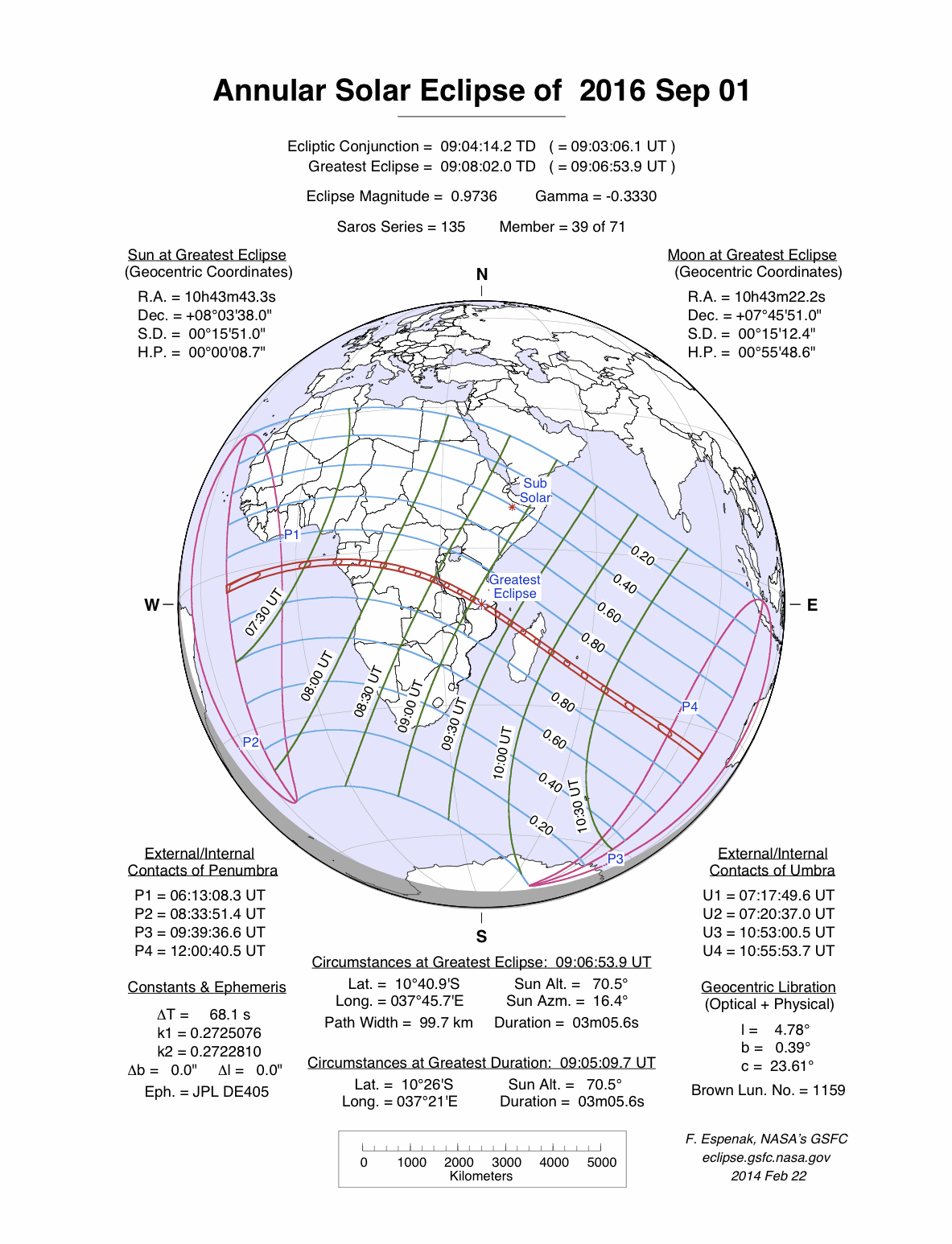
| Type | Ring-shaped |
| area |
Africa , Indian Ocean Annular: Atlantic , Central Africa , Madagascar , India |
| Saros cycle | 135 (39 of 71) |
| Gamma value | −0.3330 |
| Greatest eclipse | |
| Duration | 3 minutes 6 seconds |
| place | Mozambique |
| location | 10 ° 41 ′ S , 37 ° 46 ′ E |
| time | September 1, 2016 9:06:51 AM UT |
| size | 0.9736 |

The annular solar eclipse of September 1, 2016 was mainly visible in central Africa . The eclipse began in the middle of the Atlantic , the path with ring-shaped visibility reached Gabon just 110 kilometers further south than the totality path of the 2013 eclipse . Then the central zone crossed the African continent in a south-southeast direction, in addition to Gabon the Republic of the Congo , the Democratic Republic of the Congo , the south of Tanzania , the north of Mozambique and the center of Madagascar . Before the eclipse ended in the Indian Ocean , their zone of circular visibility was still the island of Réunion .
As a partial eclipse , however, it could be observed from almost the entire African continent.
Weather outlook
Almost in the entire area of the ring-shaped visibility there is a tropical climate , in Madagascar a subtropical climate , which makes ideal observation conditions not particularly likely. At the time of the eclipse, however, there is still the dry season, which improves the prospects, they should be best in the middle of the African continent.
Impressions

Beginning of the annular phase, Réunion

literature
- Wolfgang Held: Solar and lunar eclipses and the most important astronomical constellations up to 2017. Verlag Freies Geistesleben, Stuttgart 2005, ISBN 3-7725-2231-9 .
Web links
- solar-eclipse.de: The annular solar eclipse from September 1st, 2016
- NASA: Total Solar Eclipse of 2016 September 01
- Solar Eclipses of Saros 135
- Astro Corner: September 1, 2016 - Annular solar eclipse
|
Previous solar eclipses:
|
Later solar eclipses:
|
|||||||||
|
April 29, 2014 (circular) |
October 23, 2014 (partial) |
March 20, 2015 (total) |
September 13, 2015 (partial) |
March 9, 2016 (total) |
September 1, 2016 (circular) |
February 26, 2017 (ring-shaped) |
August 21, 2017 (total) |
February 15, 2018 (partial) |
July 13, 2018 (partial) |
August 11, 2018 (partial) |
|
|
|
|
|
|
|
|
|
|
|
|
| Lists: 20th century • 21st century • All lists | ||||||||||