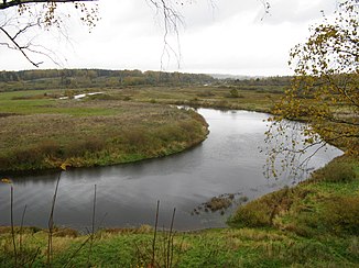
Sorot
|
Sorot Сороть |
||
|
Sorot near Trigorskoye |
||
| Data | ||
| Water code | RU : 01030000112102000028021 | |
| location | Pskov Oblast ( Russia ) | |
| River system | Narva | |
| Drain over | Velikaya → Narva → Baltic Sea | |
| origin | Michalkinskoye Lake 57 ° 5 ′ 26 ″ N , 29 ° 36 ′ 57 ″ E |
|
| Source height | 67 m | |
| muzzle |
Velikaya coordinates: 57 ° 3 ′ 57 " N , 28 ° 48 ′ 57" E 57 ° 3 ′ 57 " N , 28 ° 48 ′ 57" E |
|
| Mouth height | 63 m | |
| Height difference | 4 m | |
| Bottom slope | 0.05 ‰ | |
| length | 80 km | |
| Catchment area | 3910 km² | |
| Drain |
MQ |
28.9 m³ / s |
| Left tributaries | Lsta | |
| Small towns | Novorschew | |
|
Course of the Sorot (Сороть) in the catchment area of the Narva |
||
The Sorot ( Russian Сороть ) is a right tributary of the Velikaya in the Russian Oblast of Pskov .
The Sorot has its origin in the small lake Michalkinskoje . It flows in a predominantly westward direction through the Novorschew , Pushkinskije Gory and Beschanizy administrative districts . Eventually it meets the Velikaya, which flows north, 161 km above its confluence with Lake Peipus. The Novorschew Rajon administrative center is located on the river . The most important tributary of the Sorot is the Lsta from the left.
The Sorot has a length of 80 km. It drains an area of 3910 km². The mean discharge is 28.9 m³ / s.
Individual evidence
- ↑ a b c Sorot in the State Water Directory of the Russian Federation (Russian)

